Approximate Location Map
Large Map »
Latitude: 52.1086 / 52°6'30"N
Longitude: -2.0734 / 2°4'24"W
OS Eastings: 395068
OS Northings: 245585
OS Grid: SO950455
Mapcode National: GBR 2JM.QMQ
Mapcode Global: VHB0R.08QD
Plus Code: 9C4V4W5G+CJ
Entry Name: 29, Bridge Street
Listing Date: 11 February 1965
Grade: II
Source: Historic England
Source ID: 1386945
English Heritage Legacy ID: 474361
ID on this website: 101386945
Location: Pershore, Wychavon, Worcestershire, WR10
County: Worcestershire
District: Wychavon
Civil Parish: Pershore
Built-Up Area: Pershore
Traditional County: Worcestershire
Lieutenancy Area (Ceremonial County): Worcestershire
Church of England Parish: Pershore
Church of England Diocese: Worcester
Tagged with: Building
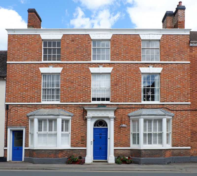
PERSHORE
SO9545 BRIDGE STREET
648-1/5/28 (East side)
11/02/65 No.29
GV II
House, now flats. Early C19 with later alterations. Red and
yellow brick in Flemish bond. Plain tile roof with eaves
raised at front, painted moulded eaves cornice and 2 brick end
stacks.
EXTERIOR: 3 storeys and cellar. 3-window range, on first floor
of 8/8 sashes with painted channelled voussoirs, keystones and
sill. Similar smaller 4/8 sashes above. On ground floor: two
canted bay-windows with pitched leaded roofs, plate glass
sashes and sill bands; central rendered doorcase with 3/4
Doric columns, stone plinth, entablature with triglyphs and
paterae, 6-panel door, fanlight with decorative glazing bars,
2 stone steps with nosings, and iron scrapers; at left end,
doorcase with moulded architrave and C20 door to side-passage;
painted moulded stone and brick plinth with cellar grille on
right.
INTERIOR: divided into flats.
Listing NGR: SO9506845585
External links are from the relevant listing authority and, where applicable, Wikidata. Wikidata IDs may be related buildings as well as this specific building. If you want to add or update a link, you will need to do so by editing the Wikidata entry.


Other nearby listed buildings
