Approximate Location Map
Large Map »
Latitude: 52.1074 / 52°6'26"N
Longitude: -2.0732 / 2°4'23"W
OS Eastings: 395082
OS Northings: 245454
OS Grid: SO950454
Mapcode National: GBR 2JM.YF9
Mapcode Global: VHB0R.09T9
Plus Code: 9C4V4W4G+XP
Entry Name: Dungannon House
Listing Date: 11 February 1965
Grade: II
Source: Historic England
Source ID: 1386979
English Heritage Legacy ID: 474395
ID on this website: 101386979
Location: Pershore, Wychavon, Worcestershire, WR10
County: Worcestershire
District: Wychavon
Civil Parish: Pershore
Built-Up Area: Pershore
Traditional County: Worcestershire
Lieutenancy Area (Ceremonial County): Worcestershire
Church of England Parish: Pershore
Church of England Diocese: Worcester
Tagged with: House
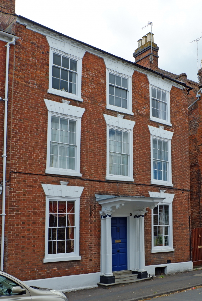
PERSHORE
SO9545 BRIDGE STREET
648-1/5/60 (West side)
11/02/65 No.74
Dungannon House
GV II
House. C17, much altered and refronted mid C18. C17 timber
frame; red brick in Flemish bond. Welsh-slate roof having
raised verge on right with brick coping, painted dentilled
eaves and 2 brick end stacks.
EXTERIOR: 3 storeys and cellar. 3-window range of sashes with
exposed boxes, painted architraves, rusticated voussoirs,
keystones and sills; 3/6 panes to 2nd floor, 6/6 to lower
floors. Central porch with half-fluted Ionic columns and
pilasters with swag capitals; oversailing panelled wooden hood
supported by heavy carved consoles; fluted wooden architrave
with paterae; 8-panel door; 3 stone steps with nosings.
Painted plinth courses with cellar grille on right.
Square-panel timber-framing visible in right return; rear
wing.
INTERIOR: hall/front room has black and white stone floor,
Adam-style fireplace with coving above, dado rail, and 6-panel
door; to rear, exposed timber-framing, including
square-panelled framing in side wall, and central fireplace;
wattle and daub in cellar wall.
(BoE: Pevsner N: Worcestershire: Harmondsworth: 1968-: 243).
Listing NGR: SO9508245454
External links are from the relevant listing authority and, where applicable, Wikidata. Wikidata IDs may be related buildings as well as this specific building. If you want to add or update a link, you will need to do so by editing the Wikidata entry.


Other nearby listed buildings
