Approximate Location Map
Large Map »
Latitude: 51.9028 / 51°54'10"N
Longitude: -2.073 / 2°4'22"W
OS Eastings: 395070
OS Northings: 222698
OS Grid: SO950226
Mapcode National: GBR 2M4.QP9
Mapcode Global: VHB1Q.0FXN
Plus Code: 9C3VWW3G+4Q
Entry Name: Clifton Lodge
Listing Date: 5 May 1972
Grade: II
Source: Historic England
Source ID: 1387369
English Heritage Legacy ID: 475325
ID on this website: 101387369
Location: Cheltenham, Gloucestershire, GL50
County: Gloucestershire
District: Cheltenham
Electoral Ward/Division: St Paul's
Parish: Non Civil Parish
Built-Up Area: Cheltenham
Traditional County: Gloucestershire
Lieutenancy Area (Ceremonial County): Gloucestershire
Church of England Parish: Cheltenham Holy Trinity
Church of England Diocese: Gloucester
Tagged with: Gatehouse
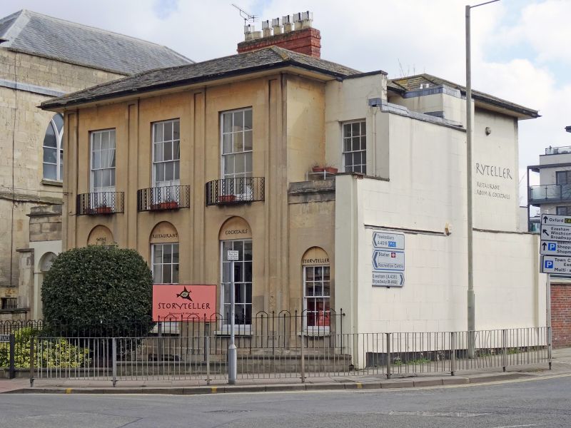
CHELTENHAM
SO9522NW NORTH PLACE
630-1/10/588 (East side)
05/05/72 No.11
Clifton Lodge
GV II
House, now restaurant. c1820-30. Ashlar over brick with hipped
slate roof and brick stacks, with wrought- and iron window
guards and railings.
EXTERIOR: 2 storeys, 3 first-floor windows, with 2-storey,
single-window range set back at right (ground-floor breaks
forward) and single-storey entrance bay at left. Ashlar
detailing includes plinth surmounted by pilasters to ends and
between windows. 6/6 sashes throughout in plain reveals and
with sills, those to ground floor surmounted by round-arched
recesses. Low parapet to right range. Entrance at left in
round-arched opening with imposts, steps to C20 part-glazed
door in moulded architrave and with fanlight with glazing
bars. Rear retains 6/6 and 2/2 horizontal-pane sashes.
INTERIOR: not inspected.
SUBSIDIARY FEATURES: elliptical balconies to first-floor, main
range have alternate sticks and lattice panels. Boot scrapers
with anthemion motif to steps.
A complete ashlar facade with good ironwork. Occupies an
important corner site at junction between North Place and St
Margaret's Terrace (qv).
(The Buildings of England: Verey D: Gloucestershire: The Vale
and The Forest of Dean: London: 1970-: 149).
Listing NGR: SO9507222698
External links are from the relevant listing authority and, where applicable, Wikidata. Wikidata IDs may be related buildings as well as this specific building. If you want to add or update a link, you will need to do so by editing the Wikidata entry.


Other nearby listed buildings
