Latitude: 51.8888 / 51°53'19"N
Longitude: -2.083 / 2°4'58"W
OS Eastings: 394387
OS Northings: 221138
OS Grid: SO943211
Mapcode National: GBR 2MB.G7G
Mapcode Global: VH947.VS5F
Plus Code: 9C3VVWQ8+GR
Entry Name: Church House
Listing Date: 26 November 1998
Grade: II
Source: Historic England
Source ID: 1387400
English Heritage Legacy ID: 475356
ID on this website: 101387400
Location: The Park, Cheltenham, Gloucestershire, GL50
County: Gloucestershire
District: Cheltenham
Electoral Ward/Division: Park
Parish: Non Civil Parish
Built-Up Area: Cheltenham
Traditional County: Gloucestershire
Lieutenancy Area (Ceremonial County): Gloucestershire
Church of England Parish: Leckhampton St Philip and St James
Church of England Diocese: Gloucester
Tagged with: House
CHELTENHAM
SO9421SW PAINSWICK ROAD 630-1/22/611 (East side) No.60 Church House
GV II
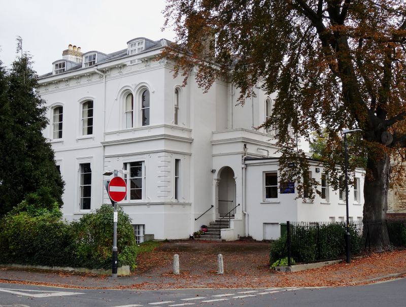
Villa, now church rooms. c1840-60 with later additions and alterations; including c1960s range to right. Stucco over brick with hipped slate roof and end gault brick stacks. EXTERIOR: 2 storeys with attics and basement, 3 first-floor windows, with blind entrance bay at right. Third bay breaks forwards and has quoins to angles at ground floor, moulded ground-floor sill band; moulded cornice over ground floor and first-floor sill band. To left part a first-floor band. Windows have tooled architraves, all with sills on feet. Ground floor has two 2/2 horizontal-pane sashes, then a tripartite window with 2/2 between 1/1 sashes, all with blind boxes. First floor has two 2/2 horizontal-pane sashes with cambered heads, then a pair of 1/1 round-arched sashes with hoodmoulds. Wide eaves on paired brackets. 2 attic roof dormers with 3/3 sashes and cambered arches, dormer to right breaks eaves and has casements. Basement has 8/8, 4/4, 8/8 and tripartite 8/8 between 2/2 sashes. Entrance at right: flight of roll-edged steps to 3-panel, part-glazed door with overlight in solid porch with round-arched opening, cornice and low parapet. INTERIOR: retains original joinery and plasterwork. Dogleg staircase has ornate iron balusters. To front room a cornice with anthemion motif. HISTORICAL NOTE: Painswick Road was laid out by Charles Baker to connect Cheltenham with Painswick following an Act of 1820. One of a good group of villas. Occupies a good corner site and has good group value with No.62 Painswick Road (qv) and Church of St Philip and St James, Gratton Road (qv). (Gloucestershire Society for Industrial Archaeology Journal: Garrett JV: Charles Baker of Painswick and Cheltenham: 1989-).
Listing NGR: SO9439021140
External links are from the relevant listing authority and, where applicable, Wikidata. Wikidata IDs may be related buildings as well as this specific building. If you want to add or update a link, you will need to do so by editing the Wikidata entry.


Other nearby listed buildings