Approximate Location Map
Large Map »
Latitude: 54.585 / 54°35'6"N
Longitude: -0.965 / 0°57'53"W
OS Eastings: 466987
OS Northings: 521582
OS Grid: NZ669215
Mapcode National: GBR PHPF.W5
Mapcode Global: WHF88.40RW
Plus Code: 9C6XH2PP+22
Entry Name: Ship House
Listing Date: 11 June 1973
Last Amended: 26 May 1999
Grade: II
Source: Historic England
Source ID: 1387569
English Heritage Legacy ID: 475544
ID on this website: 101387569
Location: Old Saltburn, Redcar and Cleveland, North Yorkshire, TS12
County: Redcar and Cleveland
Civil Parish: Saltburn, Marske and New Marske
Built-Up Area: Saltburn-by-the-Sea
Traditional County: Yorkshire
Lieutenancy Area (Ceremonial County): North Yorkshire
Church of England Parish: Brotton Parva St Margaret
Church of England Diocese: York
Tagged with: House
SALTBURN, MARSKE AND NEW MARSKE
NZ62SE SALTBURN ROAD, Old Saltburn
802-1/2/30 (East side (off))
11/06/73 Ship House
(Formerly Listed as:
SALTBURN AND MARSKE BY THE SEA
CAT NAB (SEA FRONT)
(East side (off))
Saltburn By The Sea
Ship House)
GV II
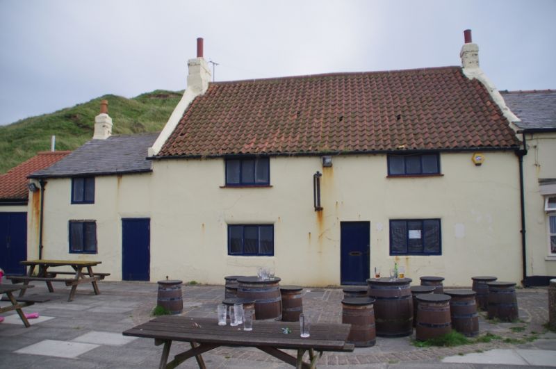
House, ground floor now Heritage Centre, local authority
tourist information centre and exhibition space. Mid-late C18
with early C19 left extension. Converted C20. Render; main
building has pantiled roof with terracotta ridge and rendered
and painted chimneys, extension Welsh slate roof with painted
chimney.
EXTERIOR: 2 storeys, 2-window range and 2 lower storeys, one
window. Main building has renewed boarded door to right of
centre; renewed 3-light windows, on ground floor almost flush
with wall, on first floor set under eaves and with tile sills,
the right window shorter and wider. Steeply pitched roof has
painted end chimneys, the right brick and the left raised in
brick. Lower left extension has renewed boarded door at right
and 2-light windows almost flush with wall; low-pitched roof
has left end chimney.
INTERIOR: shows staircase, formerly rising from small entrance
hall, now removed. Room to left of entrance has many joists,
and beam approx 1m in front of fire. Upper floor not
accessible except through private flat over adjacent public
house; can be seen from ceiling hatch in tourism office to be
in derelict condition.
Part of the original fishing settlement of Saltburn.
Listing NGR: NZ6698721582
External links are from the relevant listing authority and, where applicable, Wikidata. Wikidata IDs may be related buildings as well as this specific building. If you want to add or update a link, you will need to do so by editing the Wikidata entry.


Other nearby listed buildings
