Approximate Location Map
Large Map »
Latitude: 51.8905 / 51°53'25"N
Longitude: -2.0872 / 2°5'13"W
OS Eastings: 394095
OS Northings: 221331
OS Grid: SO940213
Mapcode National: GBR 2MB.F4N
Mapcode Global: VH947.RRY3
Plus Code: 9C3VVWR7+64
Entry Name: Whitehayes (Number 27) and Woodside (Number 29)
Listing Date: 5 May 1972
Grade: II
Source: Historic England
Source ID: 1388162
English Heritage Legacy ID: 476160
ID on this website: 101388162
Location: Tivoli, Cheltenham, Gloucestershire, GL50
County: Gloucestershire
District: Cheltenham
Electoral Ward/Division: Park
Parish: Non Civil Parish
Built-Up Area: Cheltenham
Traditional County: Gloucestershire
Lieutenancy Area (Ceremonial County): Gloucestershire
Church of England Parish: Cheltenham St Stephen
Church of England Diocese: Gloucester
Tagged with: Architectural structure
CHELTENHAM
SO9421SW TIVOLI ROAD
630-1/22/966 (West side)
05/05/72 Nos.27 AND 29
Whitehayes (No.27) and Woodside
(No.29)
GV II
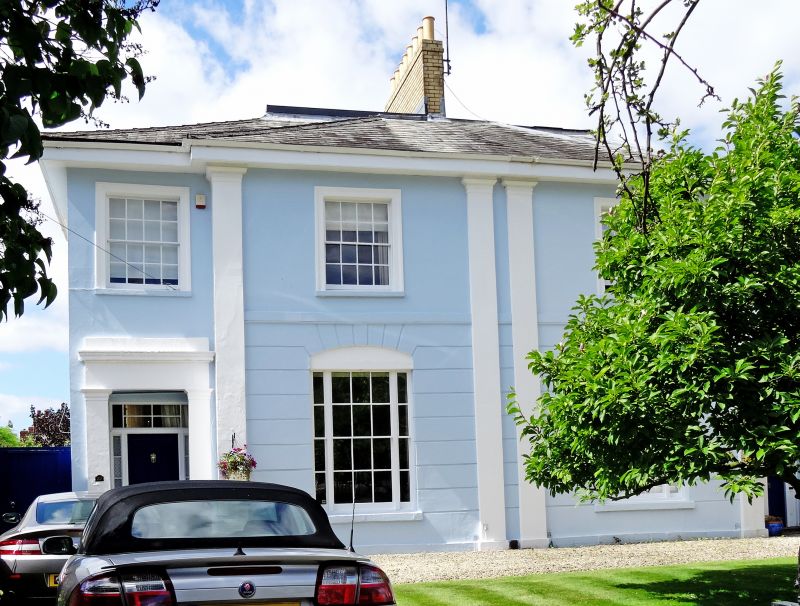
Pair of semi-detached villas. c1834-50. Stucco over brick with
hipped slate roof and gault brick party-wall stack.
EXTERIOR: 2 storeys, 1:2:1 first-floor windows. The centre
breaks forwards. Stucco detailing includes end full-height
Doric pilasters to ground-floor breakforward and 2 to
party-wall; breakforward has horizontal rustication, drawn
into voussoirs over segmental recesses to windows; first-floor
band; first-floor windows have tooled architraves. First floor
has 8/8 sashes; ground floor has tripartite windows with 6/6
between 2/2 sashes; all in plain reveals and with sills. End
entrances: architraves have Doric pilasters, frieze, cornice
and blocking course, within are 4-panel doors with sidelights
and overlights with glazing bars.
INTERIOR: noted as retaining original joinery including
panelled shutters.
HISTORICAL NOTE: houses along Tivoli Road (originally known as
Tivoli) are shown as laid out on Merrett's Map of 1834.
Listing NGR: SO9409621335
External links are from the relevant listing authority and, where applicable, Wikidata. Wikidata IDs may be related buildings as well as this specific building. If you want to add or update a link, you will need to do so by editing the Wikidata entry.


Other nearby listed buildings
