Latitude: 51.8912 / 51°53'28"N
Longitude: -2.0865 / 2°5'11"W
OS Eastings: 394140
OS Northings: 221407
OS Grid: SO941214
Mapcode National: GBR 2MB.F8S
Mapcode Global: VH947.SQ9L
Plus Code: 9C3VVWR7+F9
Entry Name: 15, Tivoli Road
Listing Date: 5 May 1972
Grade: II
Source: Historic England
Source ID: 1388158
English Heritage Legacy ID: 476156
ID on this website: 101388158
Location: Tivoli, Cheltenham, Gloucestershire, GL50
County: Gloucestershire
District: Cheltenham
Electoral Ward/Division: Park
Parish: Non Civil Parish
Built-Up Area: Cheltenham
Traditional County: Gloucestershire
Lieutenancy Area (Ceremonial County): Gloucestershire
Church of England Parish: Cheltenham St Stephen
Church of England Diocese: Gloucester
Tagged with: Building
CHELTENHAM
SO9421SW TIVOLI ROAD 630-1/22/962 (West side) 05/05/72 No.15
GV II
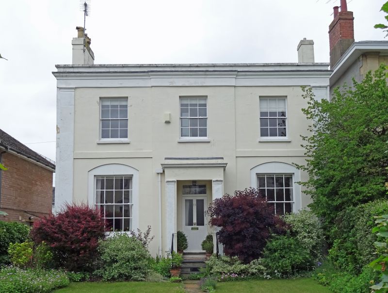
Villa. c1834-40. Stucco over brick with concealed roof and end stucco stacks. Double depth plan with central hallway. EXTERIOR: 2 storeys, 3 first-floor windows, the centre bay breaks forward. Stucco detailing includes full-height end pilasters surmounted by frieze, cornice and blocking course with copings; outer bays have first-floor band. First floor has 6/6 sashes; second floor has 8/8 sashes in wider, segmental-arched recesses; all with plain reveals and sills. Central entrance, 3 roll-edged steps to solid porch with pilasters, frieze and cornice with blocking course; within a part-glazed 4-panel door with overlight. INTERIOR: not inspected. HISTORICAL NOTE: houses along Tivoli Road (known as Tivoli) are shown as laid out, with a few built to the north end, on Merrett's Map of 1834. (The Buildings of England: Verey D: Gloucestershire: The Vale and The Forest of Dean: London: 1970-: 154).
Listing NGR: SO9413921409
External links are from the relevant listing authority and, where applicable, Wikidata. Wikidata IDs may be related buildings as well as this specific building. If you want to add or update a link, you will need to do so by editing the Wikidata entry.


Other nearby listed buildings