Latitude: 53.5986 / 53°35'54"N
Longitude: -2.4554 / 2°27'19"W
OS Eastings: 369958
OS Northings: 411432
OS Grid: SD699114
Mapcode National: GBR CV9T.6Q
Mapcode Global: WH97N.8T03
Plus Code: 9C5VHGXV+CR
Entry Name: Beggars Acre
Listing Date: 26 April 1974
Grade: II
Source: Historic England
Source ID: 1388275
English Heritage Legacy ID: 476275
ID on this website: 101388275
Location: Smithills, Bolton, Greater Manchester, BL1
County: Bolton
Electoral Ward/Division: Smithills
Parish: Non Civil Parish
Built-Up Area: Bolton
Traditional County: Lancashire
Lieutenancy Area (Ceremonial County): Greater Manchester
Church of England Parish: Halliwell St Peter
Church of England Diocese: Manchester
Tagged with: Architectural structure
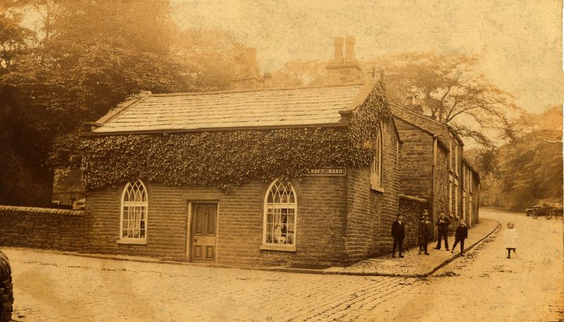
BOLTON
SD61SE SMITHILLS CROFT ROAD
797-1/1/213 (North side)
26/04/74 Beggar's Acre
II
House, possibly built as lodge. c1830. Coursed and squared
stone with slate roof.
EXTERIOR AND PLAN: single storey, 2-unit plan with central
doorway, and shorter parallel rear range. Pointed arched
windows with plain architraves and reticulated tracery, each
side of central door. Similar window set high up in gable end,
and in rear range. Axial stack to rear wing.
INTERIOR: not inspected.
Listing NGR: SD6995811432
External links are from the relevant listing authority and, where applicable, Wikidata. Wikidata IDs may be related buildings as well as this specific building. If you want to add or update a link, you will need to do so by editing the Wikidata entry.


Other nearby listed buildings