Approximate Location Map
Large Map »
Latitude: 51.5185 / 51°31'6"N
Longitude: -0.1665 / 0°9'59"W
OS Eastings: 527314
OS Northings: 181543
OS Grid: TQ273815
Mapcode National: GBR 69.TV
Mapcode Global: VHGQZ.23C8
Plus Code: 9C3XGR9M+9C
Entry Name: 245, Old Marylebone Road
Listing Date: 31 October 2001
Grade: II
Source: Historic England
Source ID: 1389501
English Heritage Legacy ID: 488183
ID on this website: 101389501
Location: Lisson Grove, Westminster, London, NW1
County: London
District: City of Westminster
Electoral Ward/Division: Bryanston and Dorset Square
Parish: Non Civil Parish
Built-Up Area: City of Westminster
Traditional County: Middlesex
Lieutenancy Area (Ceremonial County): Greater London
Church of England Parish: St Mary Bryanston Square
Church of England Diocese: London
Tagged with: Building
1900/0/10287 OLD MARYLEBONE ROAD
31-OCT-01 245
GV II
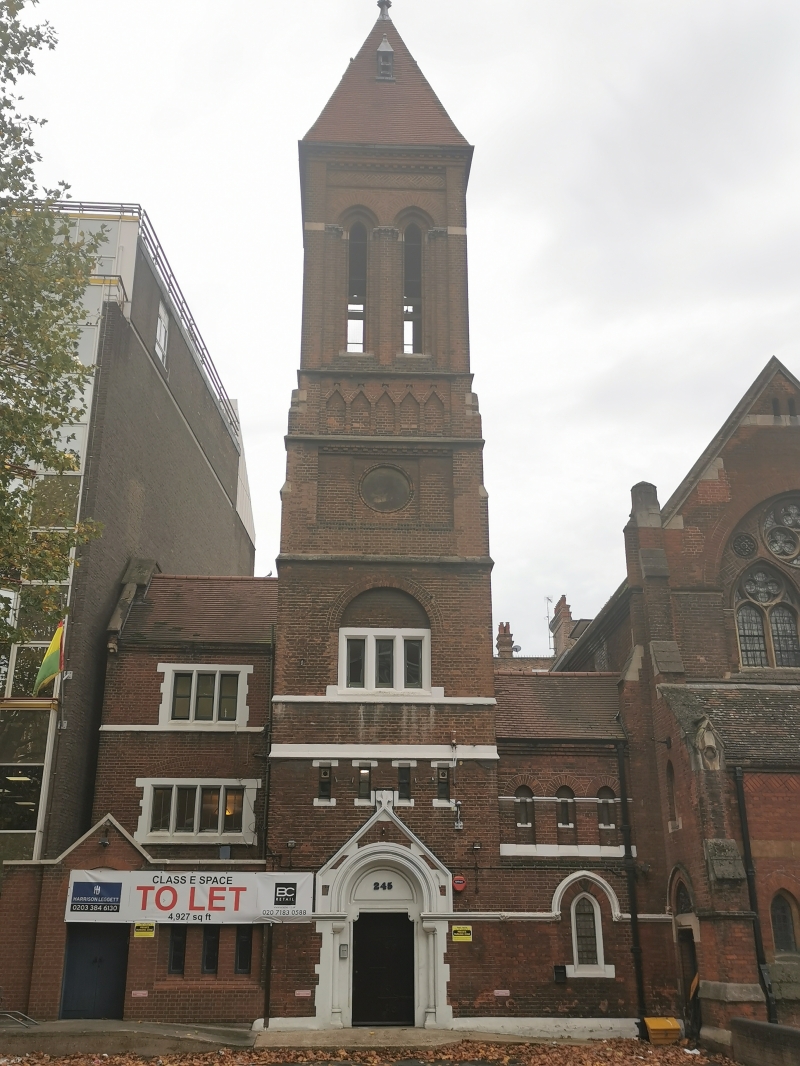
Former St Mark's School, now offices. C.1871-72 by Arthur Blomfield. Two and three storey hall with five-stage tower attached. Red brick, stone dressings, tiled roof. EXTERIOR: arched doorway of stone with plank doorset between shafts, set within gabled drip mould; moulded string course at impost level runs across to join lesser arched door to right. Four rectangular slitted lights at first floor level over entrance at second stage of tower; arcade of three lancets to right; three light window within blind arch above, to third stage. Fourth stage with blind circular recesses (probably intended for clocks) to each side beneath corbel tables. Narrow fifth stage with blind arcades of brickwork. Top stage consists of an open belfry, with two tall pointed arches per side; stone imposts. Tower terminates with a pyramidal spire with a gabled louvre to each face. INTERIOR: broad stone stair; lower room with 15-light mullioned window at south end, mullioned windows placed high up along west wall, lowered ceiling; upper floor with similar south window (compromised by insertion of fire escape), sash windows within recesses to west side, arch-braced collar-trussed roof with iron tie-rods. HISTORY: believed to have been designed by Blomfield at the same time as St Mark's Church, which was consecrated on 29th June 1872, this adjunct formed part of the mission of outreach embodied by the creation of this new parish. The builidng is identified as a school on the Ordnance Survey map of 1894-96. Together with the church and adjacent vicarage, the former school forms a notable group of High Victorian inner city religious buildings. The group was illustrated in The Architect, February 21 1880, 133.
External links are from the relevant listing authority and, where applicable, Wikidata. Wikidata IDs may be related buildings as well as this specific building. If you want to add or update a link, you will need to do so by editing the Wikidata entry.


Other nearby listed buildings
