Approximate Location Map
Large Map »
Latitude: 51.2719 / 51°16'18"N
Longitude: 0.3953 / 0°23'43"E
OS Eastings: 567184
OS Northings: 155253
OS Grid: TQ671552
Mapcode National: GBR NPQ.BR1
Mapcode Global: VHJMB.S9V9
Plus Code: 9F3279CW+Q4
Entry Name: Former Airmens Institute
Listing Date: 15 April 2004
Grade: II
Source: Historic England
Source ID: 1390913
English Heritage Legacy ID: 492499
ID on this website: 101390913
Location: Kings Hill, Tonbridge and Malling, Kent, ME19
County: Kent
District: Tonbridge and Malling
Civil Parish: Kings Hill
Built-Up Area: King's Hill
Traditional County: Kent
Lieutenancy Area (Ceremonial County): Kent
Church of England Parish: West Malling St Mary
Church of England Diocese: Rochester
Tagged with: Architectural structure
WEST MALLING
1156/0/10012 CHURCHILL SQUARE
15-APR-04 Kings Hill (former RAF West Malling)
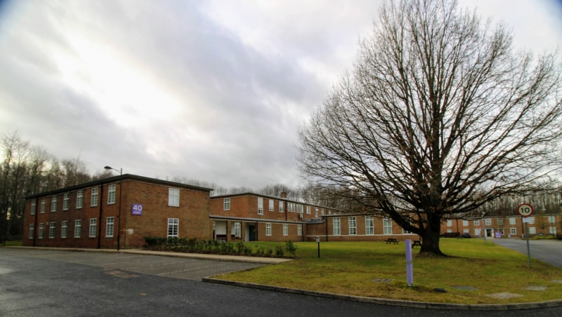
Former Airmen's Institute
GV II
Airmen's accommodation, dining room and Institute, now in commercial use. 1939-40, to 1938 design by J. H. Binge of Air Ministry's Directorate of Works and Buildings. Reinforced concrete floors and roof on stretcher bond cavity walls, roof finish not visible, originally asphalt.
PLAN: A broad-fronted U-plan, with a wide 2-storey reception block, originally with reading, games and recreation rooms, linked on its central axis to the large single-storey dining room to the rear. A single-storey link corridor each side leads to 2-storey bedroom blocks, at right angles to and brought forward from the central range. To the rear the kitchen and service areas lie to the right of the dining room.
EXTERIOR: Windows are all steel casement, mainly 2-light, with a transom and horizontal bars, set to a wood sub-frame, in slight plain reveals, and with concrete sills; the centre range has smaller 2-light in cast stone surrounds. This range has 5 windows each side of the central doorway, those to the ground floor deeper than at first floor, and to continuous lintel bands, the sillband to ground floor. A pair of part-glazed doors with overlight and sidelights is framed in painted piers with channelled capitals in stepped recessed jambs to a flat canopy with moulded edge. There is one brick stack, off-centre to right. The returned ends have a single casement above the flat roof to the links, and the back has various windows, including a deep unit to the stairs, and two escape doors from the upper level opening to the flat roofs. The link corridors have two windows to the front, and five to the rear.
The accommodation wings are in 7 x 1 bays, with deep 2-light casements at each level on the outer elevations, and a variety of openings, including a deep stair light, facing inwards; the wings project forward 6 bays, and in the centre to each is a part-glazed door on 2 steps and in channelled painted responds, to a segmental flat canopy. The short returns have one window to each level, but the rear of the left wing has a ground-floor door. These three ranges have a plain square roof edge, and a 3-course brick 'frieze' above the upper lintel band. The rear dining room is in 5 x 3 bays, with windows and detail as for the front ranges. The kitchen, to its left, has a large ventilating roof lantern, and beyond this is a large boiler room with doors, overlight and vents to the outer end, wide doors and louvres on the return, 4 roof vents, and a large square stack.
INTERIOR: Original joinery including panelled doors. The principal features are the solid string concrete staircases with terrazzo finish, hardwood swept handrails on steel Art Deco balustrades.
HISTORY: This impressive building constitutes a key element through its placing at the head of the best-preserved Art Deco influenced RAF barracks in the country, planned in a collegiate manner. It is also significant, as outlined below, for its associations with this historically important base.
From 1938, and coinciding with Bulloch's replacement by P M Stratton, new buildings and stations, including Middle Wallop and West Malling, made increasing use of concrete and flat roofs in order to respectively speed up the building process and counter the effects of shrapnel and incendiary bombs. These are all designs by the Air Ministry architect J.H. Binge, the marked horizontality of the elevations and Art Deco detail presenting a consciously modern style. The flat-roofed buildings around Churchill Square, planned in a collegiate manner with the Institute placed at their head, are the best-preserved group of their type in the country. The Institute, planned on the dispersed principles established for RAF messes from the 1920s, is the most elaborate example of this Art Deco styling, differing from the Institute building at Bicester (Oxfordshire) in having flanking accommodation wings.
From 1930 the Maidstone School of Flying used the area as a private landing ground, which was registered as Maidstone airport in 1932. A satellite of Biggin Hill within Fighter Command's strategically critical 11 Group, West Malling was opened as a fighter station in June 1940, although a series of raids in August and September 1940 rendered the airfield unserviceable for much of the Battle of Britain. It reopened in October of that year, although the station was able to accept a full station only in April 1941. It became a nightfighter station at this time, its Bristol Beaufighter pilots including Guy Gibson and Don Parker - both becoming famous names in Bomber Command, the former for his leadership of 617 Squadron in the Dams Raid and other precision attacks. It was later used by Mosquitos and Typhoons in operations against occupied Europe, including the support of 'D' Day, and became the principal station during 'Operation Diver' in 1944, the name given to the defence of the east and south-eastern coasts against the V1 bomb. It is significant, in this context, that there are no other fighter stations associated with 'Operation Diver' that have survived in a sufficiently complete state of preservation to merit listing: the other key sites in the London area - Northolt, Biggin Hill and Kenley - were placed behind the balloon barrage erected for the operation. With the end of the war, West Malling became the main rehabilitation centre for POWs returning from Germany to Britain. The base was put into 'care and maintenance' in August 1960, and was acquired in 1970 by Kent County Council: in 1972 it became a centre for dispossessed Ugandan Asians, and eventually some of the major buildings were adapted for Local Authority use (notably the Officers' Mess and Building 60), whilst others were retained and incorporated as part of a larger commercial park.
(Paul Francis, British Military Airfield Architecture (Sparkford, 1996); RAF Museum, Hendon, drawings collection; RJ Brooks, The 50th Anniversary of RAF West Malling, Tonbridge and Malling Borough Council, 1989; Bruce Barrymore Halpenny, Action Stations 8: Military Airfields of Greater London (Cambridge, 1984), pp.213-7)
TQ6718455247
External links are from the relevant listing authority and, where applicable, Wikidata. Wikidata IDs may be related buildings as well as this specific building. If you want to add or update a link, you will need to do so by editing the Wikidata entry.


Other nearby listed buildings
