Approximate Location Map
Large Map »
Latitude: 50.366 / 50°21'57"N
Longitude: -4.1551 / 4°9'18"W
OS Eastings: 246826
OS Northings: 54010
OS Grid: SX468540
Mapcode National: GBR R87.K1
Mapcode Global: FRA 2852.K2K
Plus Code: 9C2Q9R8V+CX
Entry Name: Millbay Docks, Inner Basin
Listing Date: 6 October 2005
Grade: II
Source: Historic England
Source ID: 1391484
English Heritage Legacy ID: 495458
ID on this website: 101391484
Location: Stonehouse, Plymouth, Devon, PL1
County: City of Plymouth
Electoral Ward/Division: St Peter and the Waterfront
Parish: Non Civil Parish
Built-Up Area: Plymouth
Traditional County: Devon
Lieutenancy Area (Ceremonial County): Devon
Church of England Parish: Plymouth St Peter and the Holy Apostles
Church of England Diocese: Exeter
Tagged with: Architectural structure
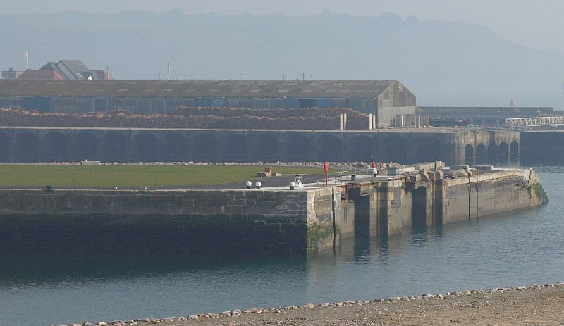
740-1/0/10075 MILLBAY DOCKS
06-OCT-05 Millbay Docks, Inner Basin
GV
II
Building: Civil dock, comprising inner basin formed of slightly battered walls of the North and East Quays and the inner face of Clyde or Glasgow Quay to the south.
Date: Constructed between 1852 and 1856 as part of a major programme of improvements to existing wharfs on the eastern side of the inlet dating from the 1820s and 1840s.
Engineer: The arrangement of the docks, of which the inner basin forms a significant part, is accredited to Isambard Kingdom Brunel, (1806-1859) Civil Engineer.
Materials: Constructed of dressed and regularly and irregularly coursed finely jointed ashlar Grey Devon limestone with copings of dressed and tooled local granite. Treads of the recessed stairs are also formed of local dressed granite.
Plan: Rectangular basin, broadly aligned east - west, comprising North Quay, East Quay and the inner face of the Glasgow Quay, now bordered to the west by the C20th infill of the ferry terminal. The angles that form the junctions of both North Quay and east Quay, and East quay and Glasgow Quay accommodate sets of curved and recessed access stairs, fully incorporated into the slightly battered wall to the quays.
Façade: North and East Quays comprise extensive lengths of slightly battered quay wall constructed in irregularly coursed dressed 'fitted rubble' masonry with a flush granite coping. Glasgow Quay comprises a length of slightly battered quay wall constructed regularly coursed, lightly rusticated ashlar masonry.
Subsidiary features: North, East and Glasgow Quays have an assortment of cast iron bollards and mooring ties set both within and behind the granite copings of varying types and dates which contribute to the character of the structure.
History: The inner and outer basins (the latter not included in the list) at Millbay were constructed following the acquisition of the site by the Great Western Dock Company in 1846. The aim of the company was to develop and expand the existing facility of quays and wharfs focused on the lower eastern shore of the inlet initiated by Thomas Gill for the transport of limestone from his adjacent quarries in the 1820s and reconstructed by James Rendell in 1844. The aspiration of the Great Western Dock Company was to develop Millbay as a deep water facility that could combine with the newly arrived railway. The Company duly instructed I. K. Brunel to develop a comprehensive facility comprising the inner basin, part of the outer basin, the connecting lock, the graving dock and associated pump house, the outer East Quay and necessary warehousing. The connecting lock between both basins was re-sited further to the east of its original position between 1897 and 1902, the Glasgow and (now lost) south Quay were also widened on the southern seaward side at this time. The western part of the basin and the Graving Dock were both in-filled in 1972. This new ground now forms the western limit of the basin.
Sources:
'Industrial Archaeology of Plymouth' - 2nd edition 1980, chapter by Gaskill-Brown.
'New Maritime History of Devon' - Vol. 2 - Duffy
Dictionary of National Biography, I. K. Brunel - R Angus Buchanan
Map of the port for the Great Western Railway, West Devon Records Office accession number 772/2.
Evaluation of Importance:
Despite subsequent alteration and infilling, the substantial remains of the inner basin of Millbay Docks, comprising the North, East and Glasgow Quays, are of national importance in the context of surviving C.19th civil port facilities. In terms of their quality of construction, degree of survival and their confirmed attribution to I.K. Brunel, one of the great engineers of the 'heroic age' of British engineering, they are duly accorded the statutory protection conferred here.
External links are from the relevant listing authority and, where applicable, Wikidata. Wikidata IDs may be related buildings as well as this specific building. If you want to add or update a link, you will need to do so by editing the Wikidata entry.


Other nearby listed buildings
