Approximate Location Map
Large Map »
Latitude: 52.49 / 52°29'24"N
Longitude: -1.9124 / 1°54'44"W
OS Eastings: 406045
OS Northings: 288014
OS Grid: SP060880
Mapcode National: GBR 5X5.M8
Mapcode Global: VH9YW.SPV0
Plus Code: 9C4WF3RQ+22
Entry Name: 116, SPENCER STREET (See details for further address information)
Listing Date: 29 April 2004
Grade: II
Source: Historic England
Source ID: 1392810
English Heritage Legacy ID: 505851
ID on this website: 101392810
Location: Hockley, Birmingham, West Midlands, B18
County: Birmingham
Parish: Non Civil Parish
Built-Up Area: Birmingham
Traditional County: Warwickshire
Lieutenancy Area (Ceremonial County): West Midlands
Church of England Parish: Birmingham St Paul
Church of England Diocese: Birmingham
Tagged with: Building
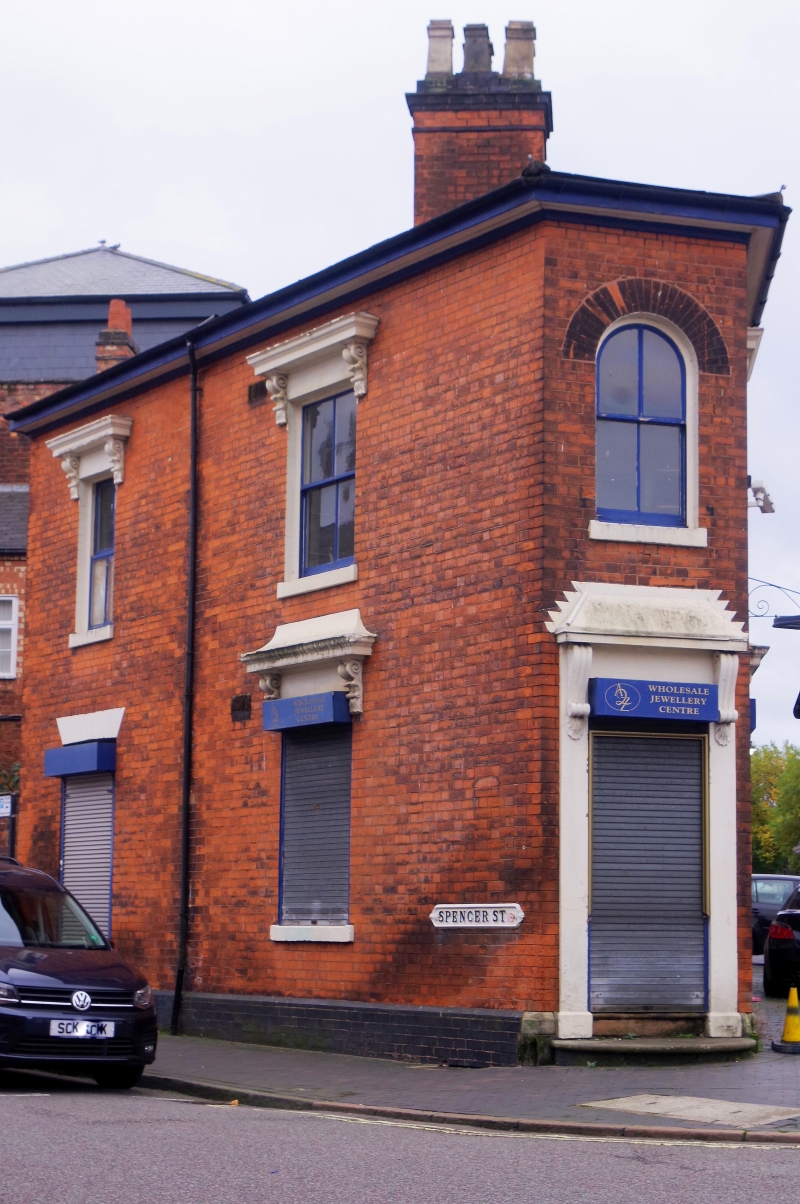
BIRMINGHAM
997/0/10315 SPENCER STREET
29-APR-04 116
VYSE STREET
85
GV II
Small manufactury. Mid-C19, with late C19 additions and alterations. Red brick with blue brick plinth and painted stone dressings. Tall gable stacks with corbelled caps, gable copings and a slate roof covering.
PLAN: Triangular street corner site, the Spencer Street frontage returning at an acute angle from Vyse Street and with rear workshop range extending the full depth of the plot.
EXTERIOR: Vyse Street range of 4 bays, 2 storeys, the northernmost bay a late C19 addition. Earlier 3-bay symmetrical front with central doorway within moulded surround, with altered panelled door set within deep panelled reveal. Semi-circular arched overlight with moulded surround set beneath gauged brick arch. Flanking windows with margin glazing to upper sashes shallow bracketed hoods above which the flat lintels extend. Margin glazed upper floor sashes, the openings detailed as below. Added bay to left with stacked sashes, with canopied ground floor hood. Wedge-shaped end with blocked doorway beneath shallow canopied hood and semi-circular arch-headed 2 over 2 pane sash window above. Spencer Street elevation of 2 bays, with stacked sash window below bracketed hoods. Attached steeply-ramped boundary wall to left adjoins end of storeyed monopitch shopping range extending eastwards from rear of Vyse Street frontage.
HISTORY: The building is shown on the Piggot-Smith map of 1855-62 with a small rear range, suggesting that by this time it was already in industrial use. The 1889 Ordnance Survey map shows the building in its present form, with an added bay at the north end and a rear workshop range extending to the Spencer Street frontage.
A small evolved manufactory of c.1850, developed from a dwelling and retaining clear evidence of adaptation and expansion in the later part of the C19, and demonstrating the dynamic growth of a specialist industrial quarter of Birmingham now recognised as being of international significance.
External links are from the relevant listing authority and, where applicable, Wikidata. Wikidata IDs may be related buildings as well as this specific building. If you want to add or update a link, you will need to do so by editing the Wikidata entry.


Other nearby listed buildings
