Approximate Location Map
Large Map »
Latitude: 51.5083 / 51°30'29"N
Longitude: -0.0791 / 0°4'44"W
OS Eastings: 533407
OS Northings: 180563
OS Grid: TQ334805
Mapcode National: GBR VF.DH
Mapcode Global: VHGR0.LC13
Plus Code: 9C3XGW5C+89
Entry Name: HM Tower of London Liberty Boundary Markers
Listing Date: 18 August 2010
Grade: II
Source: Historic England
Source ID: 1393921
English Heritage Legacy ID: 508103
ID on this website: 101393921
Location: Wapping, Tower Hamlets, London, EC3R
County: London
District: Tower Hamlets
Electoral Ward/Division: Tower
Parish: Non Civil Parish
Built-Up Area: City of London
Traditional County: Middlesex
Lieutenancy Area (Ceremonial County): City of London
Church of England Parish: All Hallows-by-the-Tower
Church of England Diocese: London
Tagged with: Tower Boundary marker
627/0/10287 HM Tower of London Liberty Boundary Ma
18-AUG-10 rkers
GV II
8 boundary markers, 1868 and later. The markers are located within the jurisdiction of two neighbouring London authorities: the City and Tower Hamlets; the 8 designated markers that fall within the City of London are described here (ref. 508104 for Tower Hamlets).
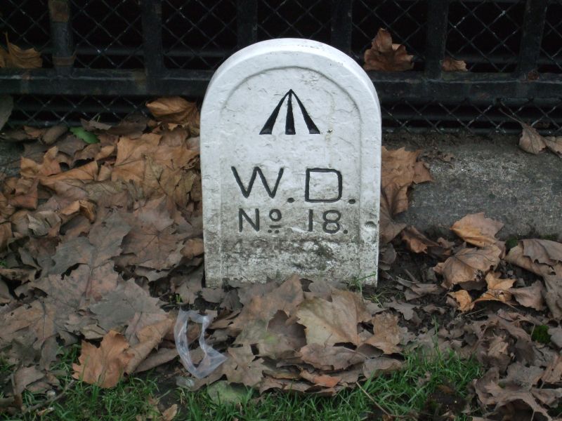
The 22 surviving boundary markers are arranged in an irregular arc from Tower Stairs in the west to Tower Bridge in the east. Some 13 of the markers are identical in form, being flat round-topped iron posts bearing with the initials WD with the Pheon, or broad arrow symbol, denoting Board of Ordnance ownership (represented by ^ in this text) and their number in the sequence; these may belong to the set installed by the War Department in 1868, although some have since been relocated or renewed. The others vary widely in form and appearance, and can only be dated approximately if at all.
#1: Square stone panel inscribed 'W^D No.1. Boundary 12' 0" West', set into the western wall of Tower Stairs. (The notional termination point of the boundary line is further to the west, at a point now in the midst of the foreshore.) This part of the wall was renewed when Tower Dock was filled in after WWII, and the marker presumably dates from this time. TQ3339780522
#2: Stone panel inscribed '^ WD', at the base of boundary wall to east of Three Quays House. The lower part of the panel, presumably bearing its number in the sequence, is below ground level. This marker is probably identical with the 'stone in wall' recorded in the 1861 survey. TQ3340280542
#3: Painted iron post with rounded top, inscribed '^ W.D. No.3.', at base of boundary wall to north of Three Quays House. Presumably renewed after 1967, when it is still recorded as being of stone. TQ3340780563
#4: Painted iron post with rounded top, inscribed '^ W.D. No.4.', at base of boundary wall to north of Three Quays House. Possibly of 1868. TQ3339880565
#9: Square metal plaque with embossed inscription reading '9 TL BM', set into road surface at corner of Trinity Square and Muscovy Street. Date unknown, but probably mid C20. TQ3346080750
#11: Painted iron post with rounded top, inscribed '^ W.D. No.11.', at base of wall facing Trinity Square in front of Trinity House (Grade I). Possibly of 1868. TQ3354680798
#12: Painted iron post with rounded top, inscribed '^ W.D. No.12.', at base of wall facing Cooper's Row in front of Trinity House (Grade I). Possibly of 1868. TQ3354680812
#21: Painted iron post with rounded top, inscribed '^ W.D. No.21', at base of wall to London Metropolitan University building facing Minories. Possibly of 1868, renewed or relocated after wartime bombing. TQ3367880789
Two surviving markers are excluded from the listing: #10, which was installed inside the Port of London Authority building (Grade II*) on the latter's completion in 1922, and is already included in that listing, and #15, a commemorative plaque set up in 1992.
HISTORY: From the middle ages until the late C19, the Tower of London and its environs - referred to as the Tower Liberty or Liberties - had a special administrative status. As a royal palace and garrison the Tower itself was a self-governing entity, distinct from the neighbouring City of London and County of Middlesex for the purposes of taxation, law enforcement and military service. At some point, seemingly by the early C13, its prerogatives were extended to cover the strategically important area immediately beyond its outer walls, comprising Petty Wales to the west, Tower Hill to the north and what is now St Katherine's Way to the east; for reasons of defence this buffer zone was to be kept free of buildings, although as London expanded to the east a degree of encroachment was inevitable. Disputes between the City and the Tower over the precise extent of their relative jurisdictions were rife in the C16, and created the impetus for a legal judgment of 1536 describing the exact boundaries of the Liberty, and for the first mapping-out of those boundaries in Haiward and Gascoyne's survey of 1597. The Tower's sphere of influence reached its maximum extent in 1686, when additional parcels of royal land in Spitalfields, East Smithfield and Little Minories were added to its domain.
The Liberty declined in importance during the C19: the outlying areas were removed from its jurisdiction, its legal authority was gradually reduced before being merged into that of the County of London in 1894, and its subsumption into the London Borough of Stepney in 1900 removed the last of its administrative responsibilities. It maintained a ceremonial existence, however: in a procession still held every third Ascension Day, the choir of St Peter ad Vincula Church ceremonially beat the boundary, delineated by a series of marker posts originally standardised by the War Department in 1868 and periodically renewed since. Bombing during the London Blitz and post-war road-widening led to the loss of many of the markers, although some were replaced or relocated. 22 of the 31 boundary points are still marked.
SOURCES: Survey notes and drawings held by the National Archives (notably WO 94/89 and WORK 31/2225) and Historic Royal Palaces (notably TOL 3397 and TOL 05/031)
John Charlton (ed.), The Tower of London: its Buildings and Institutions (1978).
Anna Keay, The Elizabethan Tower of London (2001).
Glanville Group, Boundary Marker Report for Historic Royal Palaces (September 2008).
REASONS FOR DESIGNATION: The Tower Liberty boundary markers are listed at Grade II for the following principal reason:
* Historic interest: as material witnesses to the Royal Liberty of the Tower of London, and its historic boundaries.
The Tower Liberty boundary markers, set up at various dates from 1868 onwards, are recommended for designation at Grade II for the following principal reason:
* Historic interest: as material witnesses to the Royal Liberty of the Tower of London, and of its historic boundaries.
External links are from the relevant listing authority and, where applicable, Wikidata. Wikidata IDs may be related buildings as well as this specific building. If you want to add or update a link, you will need to do so by editing the Wikidata entry.


Other nearby listed buildings
