Approximate Location Map
Large Map »
Latitude: 51.4536 / 51°27'12"N
Longitude: 0.2941 / 0°17'38"E
OS Eastings: 559492
OS Northings: 175229
OS Grid: TQ594752
Mapcode National: GBR Y0.0V3
Mapcode Global: VHHNW.1QTK
Plus Code: 9F32F73V+CJ
Entry Name: Garden Bridge, Ingress Park
Listing Date: 3 October 2012
Grade: II
Source: Historic England
Source ID: 1410227
ID on this website: 101410227
Location: Swanscombe, Dartford, Kent, DA9
County: Kent
District: Dartford
Civil Parish: Swanscombe and Greenhithe
Traditional County: Kent
Lieutenancy Area (Ceremonial County): Kent
Church of England Parish: Greenhithe St Mary
Church of England Diocese: Rochester
Tagged with: Architectural structure
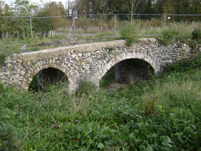
Garden bridge at Ingress Park, dating either from the 1760s when 'Capability' Brown was employed to landscape the north-east of the Ingress Abbey estate or the 1830s when James Harmer was adding new garden structures. The bridge is aligned along a raised estate footpath and spans a sunken path.
MATERIALS: constructed of flints, mainly not faced, and a mixture of red and yellow bricks of two sizes bonded with hard lime mortar.
DESCRIPTION: the bridge has two arches, the eastern arch larger with a segmental arch of alternate headers and stretchers, and a smaller western round-headed arch has a double row of headers. The eastern arch is 2.85 metres wide, the western 1.04 metres wide. Internally both arches have flint walls and barrel-vaulted brick roofs. The quoins of the internal piers are built in blocks of three or four brick courses with the flint work tied in. The north side was fully exposed at the time of survey with the flint work at the ends curving northwards. The east side finishes as it meets the eastern bank of the sunken path but the western side is truncated. The south side was not fully exposed at the time of inspection but enough was visible to show that it was extant.
'Ingryce' was endowed in 1363 by Edward III to the nuns of Dartford Priory, who used it until the 1530s, as a farm, and for chalk quarrying. After the suppression the crown granted it to John Bere of Dartford and in 1562 Queen Elizabeth granted it jointly to John Bere and Sir Edward Darbyshire. In 1649 there is reference to a 'Mansion' and in that year the estate passed to Captain Edward Brent of Southwark for £1122. Between 1698 and 1737 the estate was owned by Jonathan Smith who was Sheriff of Kent from 1721: a print of 1720 by Badeslade shows a six bay house surrounded by walled gardens, parterres and avenues.
In 1748 the house was conveyed to Viscount Duncannon, who became Earl of Bessborough in 1758. Changes to the park were carried out by Sir William Chambers and the Earl of Bessborough is likely to have created some of the follies in the grounds, including the Cave of the Seven Heads, the South Tunnel and the Flint Cave. In 1760 the estate was sold to John Calcraft, a former army agent and later the MP for Rochester. Calcraft retained Sir William Chambers and from 1763 employed Lancelot 'Capability' Brown at the cost of £1000 to landscape the parkland to the north-east of the estate, the approach to the house through the grounds, and the sloping of the ground towards the house. The parkland appears to have spread eastwards towards Swanscombe. Calcroft appears to have constructed other follies, Lover's Arch and the Flint Alcove, and he also re-sited the kitchen garden. Greenhithe and its parkland appear on the 1769 'A Topographical Map of the county of Kent' by Andrews and Dury showing an H-shaped main house with formal gardens and tree-lined avenues. In 1772 the estate passed to Calcroft's son who sold it to John Disney Roebuck. In 1799 the estate was bought by William Havelock who partially demolished the house after 1815. The garden bridge is said to appear on an 1810 Salvage Map.
In 1833 James Harmer, Alderman of the City of London, rebuilt Ingress Abbey, possibly reusing some elements of the earlier house in the east wing, and also built The Grange, the East Tunnel and laid out a flower garden. The estate was left to his daughter in 1853. The First Edition Ordnance Survey map of 1868 depicts Lovers Lane running on a raised bank and appearing to continue after a slight turn at a bridge westwards through Ingress Park. A path from Ingress Cottages within the park leads under the bridge and continues northwards. By the 1884 Ordnance Survey map stones are marked, probably parish boundary markers, and by the 1897 edition 'Barge Yard Wharf' has been added next to the shore of the River Thames. Parts of the parkland were sold off after 1903 and Ingress Abbey Paper Mills are shown to the east of the park on the 1909 Ordnance Survey map.
During the First World War Ingress Abbey was used as an army hospital and by 1922 both house and grounds were purchased by the Thames Nautical Training College. A local resident remembers the north side of the bridge being visible during the Second World War with a door fixed on it to form a bomb shelter. Ingress Abbey and its garden buildings became dilapidated but the house was listed at Grade II in 1970, the stable block in 1982 and the known garden buildings were listed in 1997. Re-development of the site began in 1997 and Ingress Abbey became the centrepiece of a large residential development.
The garden bridge at Ingress Park is listed at Grade II for the following principal reasons:
* Architectural interest: a late C18 or early C19 flint and brick garden bridge with an elliptical and a round-headed arch built as part of a garden or estate walk which afforded views of the Thames;
* Degree of Survival: it survives substantially intact;
* Group Value: one of a number of Ingress Abbey estate buildings including Ingress Abbey, its former stables, follies, tunnels and other garden structures.
External links are from the relevant listing authority and, where applicable, Wikidata. Wikidata IDs may be related buildings as well as this specific building. If you want to add or update a link, you will need to do so by editing the Wikidata entry.


Other nearby listed buildings
