Approximate Location Map
Large Map »
Latitude: 53.2282 / 53°13'41"N
Longitude: -1.2008 / 1°12'2"W
OS Eastings: 453451
OS Northings: 370431
OS Grid: SK534704
Mapcode National: GBR 8D6.P6S
Mapcode Global: WHDFL.J3FZ
Plus Code: 9C5W6QHX+7M
Entry Name: Nether Langwith War Memorial
Listing Date: 9 December 2014
Grade: II
Source: Historic England
Source ID: 1421787
ID on this website: 101421787
Location: Nether Langwith, Bassetlaw, Nottinghamshire, NG20
County: Nottinghamshire
District: Bassetlaw
Civil Parish: Nether Langwith
Built-Up Area: Langwith
Traditional County: Nottinghamshire
Lieutenancy Area (Ceremonial County): Nottinghamshire
Church of England Parish: Whaley Thorns St Luke
Church of England Diocese: Derby
Tagged with: Memorial
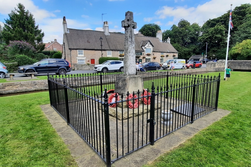
War memorial, unveiled in 1920. Restored and re-dedicated in 2012-3.
War memorial, unveiled in 1920. Restored and re-dedicated in 2012-3.
The memorial, of Roche Abbey stone, comprises a rough-hewn Celtic cross set on a boulder-like plinth, its front face smooth and carrying the names of the men commemorated. An inverted sword of remembrance is carved on the upper part of the cross shaft, while the lower part of the shaft carries the inscription TO THE GLORY OF GOD AND IN HONOURED MEMORY OF (on the north side) and 1914-1918 (on the south side). The plinth stands on a base of large, rough-hewn slabs. The plinth carries inscriptions on the north and south sides - the inscription on the north side gives the 12 names of the men lost, together with 1914-1918, while the inscription on the south side reads ALSO IN HONOURED MEMORY OF (4 names) / 1939-1945.”
This List entry has been amended to add sources for War Memorials Online and the War Memorials Register. These sources were not used in the compilation of this List entry but are added here as a guide for further reading, 24 January 2017.
This list entry was subject to a Minor Amendment on 8 October 2021 to reformat the text to current standards.
The war memorial, in remembrance of the men of Nether Langwith lost in the First World War, was unveiled on 8 August 1920 by Mrs Warner Turner of Cuckney House and dedicated by the vicar, the Revd J W Smith. The monument was designed and constructed by Lidster & Brammer of Worksop. The monument was restored and re-dedicated in 2012/3. The memorial steps were replaced and a flagstone base and renovated fence were installed around the memorial. A new plaque commemorating the fallen of the Second World War was added.
The war memorial, on the village green on Main Road, Nether Langwith, is listed at Grade II for the following principal reasons:
* Historic interest: as an eloquent witness to the tragic impact of world events on the local community, and the sacrifice it made in the conflicts of the C20;
* Architectural interest: the memorial is a thoughtfully designed Celtic cross with good carved detailing;
* Group value: for its proximity to the Jug and Glass Inn and Brook House farm, both listed at Grade II.
External links are from the relevant listing authority and, where applicable, Wikidata. Wikidata IDs may be related buildings as well as this specific building. If you want to add or update a link, you will need to do so by editing the Wikidata entry.


Other nearby listed buildings
