Approximate Location Map
Large Map »
Latitude: 50.7394 / 50°44'21"N
Longitude: -2.7879 / 2°47'16"W
OS Eastings: 344498
OS Northings: 93609
OS Grid: SY444936
Mapcode National: GBR PN.DWJ2
Mapcode Global: FRA 5714.3PQ
Plus Code: 9C2VP6Q6+QR
Entry Name: Symondsbury War Memorial
Listing Date: 18 August 2015
Grade: II
Source: Historic England
Source ID: 1427997
ID on this website: 101427997
Location: St John the Baptist's Church, Symondsbury, Dorset, DT6
County: Dorset
Civil Parish: Symondsbury
Traditional County: Dorset
Lieutenancy Area (Ceremonial County): Dorset
Church of England Parish: Symondsbury St John the Baptist
Church of England Diocese: Salisbury
Tagged with: Memorial
First and Second World War memorial. Erected c1920 with the names of the Fallen of the Second World War added after 1945.
First and Second World War memorial. Erected c1920 with the names of the Fallen of the Second World War added after 1945.
MATERIALS: granite set in a concrete foundation.
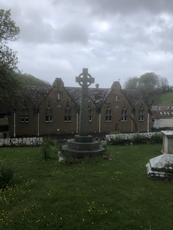
DESCRIPTION: the war memorial stands in the churchyard of the church of St John the Baptist, near the centre of Symondsbury, and faces south. It is immediately south of the Grade I listed medieval church and north of the Grade II listed late C19 Church of England primary school. The memorial comprises a rough-hewn granite cross with Celtic head, enriched by raised interlace and knotwork, upon on a tapering shaft c2.5m high that rises from a three-tier stepped octagonal plinth 0.7m high. In the centre of the cross is the Chi-Rho symbol; a monogram abbreviating the name of Jesus Christ. The front of the middle step of the plinth is inscribed IN REMEMBRANCE/ OF SYMONDSBURY MEN/ WHO FELL IN/ THE GREAT WAR/ 1914-1918. On six sides 28 names are inscribed. The front of the lower step is inscribed 1939-1945/ (NAMES), with five names of the Fallen. The memorial is set in a square concrete foundation.
This List entry has been amended to add sources for War Memorials Online and the War Memorials Register. These sources were not used in the compilation of this List entry but are added here as a guide for further reading, 7 December 2016.
The aftermath of the First World War saw a huge wave of public commemoration with tens of thousands of memorials erected across the country. One such memorial was erected in c1920 to commemorate 28 residents of Symondsbury who died during the conflict. A further inscription was added to the memorial following the Second World War, to commemorate five residents who lost their lives during that conflict.
Symondsbury war memorial, which stands in the churchyard of the church of St John the Baptist, is listed at Grade II for the following principal reasons:
* Historic interest: as an eloquent witness to the tragic impact of world events on the local community, and the sacrifice it made in the conflicts of the C20;
* Design: an elegant Celtic cross enriched by raised interlace and knotwork, and bearing the Chi-Rho symbol, set on a shaft rising from a stepped octagonal plinth;
* Group value: with the Grade I listed church of St John the Baptist and the Grade II listed Symondsbury Church of England Primary School.
External links are from the relevant listing authority and, where applicable, Wikidata. Wikidata IDs may be related buildings as well as this specific building. If you want to add or update a link, you will need to do so by editing the Wikidata entry.


Other nearby listed buildings
