Approximate Location Map
Large Map »
Latitude: 53.4019 / 53°24'6"N
Longitude: -2.9832 / 2°58'59"W
OS Eastings: 334726
OS Northings: 389900
OS Grid: SJ347899
Mapcode National: GBR 74Q.PH
Mapcode Global: WH877.4RPF
Plus Code: 9C5VC228+PP
Entry Name: 50 Duke Street, including 2 and 4 York Street and 27 Henry Street
Listing Date: 21 July 2004
Grade: II
Source: Historic England
Source ID: 1429431
Also known as: 48 and 50 Duke Street
50 Duke Street
ID on this website: 101429431
Location: Liverpool, Merseyside, L1
County: Liverpool
Electoral Ward/Division: Riverside
Parish: Non Civil Parish
Built-Up Area: Liverpool
Traditional County: Lancashire
Lieutenancy Area (Ceremonial County): Merseyside
Church of England Parish: St Luke in the City Team
Church of England Diocese: Liverpool
Tagged with: Building
The asset was previously listed twice also under List entry 1206603. This entry was removed from the List on 30th September 2015.
392/0/10198
DUKE STREET,
No. 50
GV II
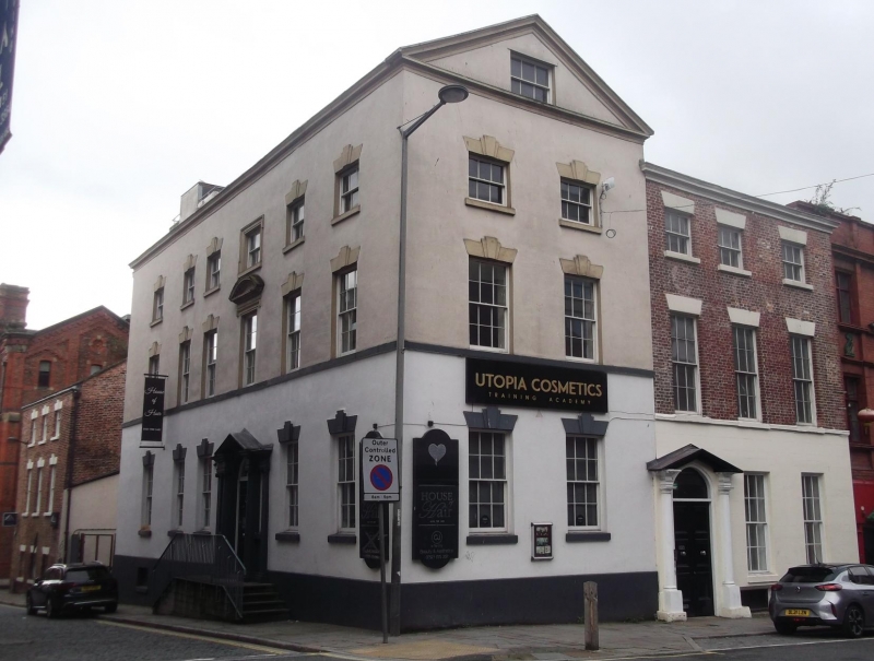
Former dwelling with associated warehousing, later converted to commercial use, and empty at the time of inspection (September 2003) Late C18,with later C19 and C20 alterations and additions. Brick with channelled and plain stucco finishes, coped gable to Duke Street frontage, and concrete tile roof covering.
PLAN: L-shaped plan, extending the full length of the plot between Duke Street and Henry Street.
EXTERIOR: Duke Street elevation of 5 bays and 3 storeys on a sloping site, the ground floor with deeply channelled stucco finish. Taller pedimented gable to left, with lower 3-bay range to right incorporating altered doorway with shallow open pediment to added doorcase set in front of original. Wide doorway with double 3-panel doors below altered fanlight. To either side, 2 tall 6 over 6 pane sash windows, the heads and cills to the left-hand openings set higher than those to the right-hand bays. Above the latter are matching tall first floor sash windows set below painted wedge lintels. The first floor windows to the left of the doorway are smaller 6 over 6 pane sashes, their heads still set above the level of those to the right. All 5 upper floor windows are set at the same level, with 3 over 3 pane sash frames. The right-hand 3 bays are set below a moulded eaves cornice. The openings below the pedimented gable have tripartite wedge lintels. 6 bay elevation to Henry Street with detailing matching that of the pedimented gable and with altered doorway to bay 3. Further left, a single storeyed building links the former dwelling to a 3 bay, 3 storeyed building with window openings, formerly with multi pane sash frames to all 3 floors, those to the ground floor blocked, all the openings with tripartite lintels. South gable with single opening to each floor, the ground floor opening a wide double doorway.
INTERIOR: Not inspected.
HISTORY: The building complex is sited a short distance to the north east of Steers Dock, on a street frontage known to have been developed by 1769. No. 50 Duke Steet and its attached subsidiary buildings are shown on Horwood's 1803 map of Liverpool and again on the large-scale Ordnance survey map of 1848. Goad's Fire Insurance plan of 1888 identifies no.27 Henry Street as a warehouse.
The complex made up of No.50 Duke Street (incorporating No.2 York Street) and the adjoining warehouse at No.4 York Street, ( incorporating No.27 Henry Street) is of both special architectural and historic interest, as a rare surviving example of late C18 merchant's housing with associated warehousing characteristic of the area surrounding Steer's Dock, and as an indicator of the extent and nature of the historic urban landscape associated with the earliest phases of development of the internationally-significant port of Liverpool.
Originally listed on 19 June 1985 as Nos. 48 and 50 Duke Street (Ref: 392/30/400)
External links are from the relevant listing authority and, where applicable, Wikidata. Wikidata IDs may be related buildings as well as this specific building. If you want to add or update a link, you will need to do so by editing the Wikidata entry.


Other nearby listed buildings
