Approximate Location Map
Large Map »
Latitude: 51.7302 / 51°43'48"N
Longitude: -2.2739 / 2°16'25"W
OS Eastings: 381180
OS Northings: 203537
OS Grid: SO811035
Mapcode National: GBR 0LC.FY0
Mapcode Global: VH94X.JRRZ
Plus Code: 9C3VPPJG+3C
Entry Name: King's Stanley War Memorial
Listing Date: 15 April 2016
Grade: II
Source: Historic England
Source ID: 1433989
ID on this website: 101433989
Location: King's Stanley, Stroud, Gloucestershire, GL10
County: Gloucestershire
District: Stroud
Civil Parish: King's Stanley
Built-Up Area: Stroud
Traditional County: Gloucestershire
Lieutenancy Area (Ceremonial County): Gloucestershire
Church of England Parish: Kings Stanley
Church of England Diocese: Gloucester
Tagged with: War memorial Memorial
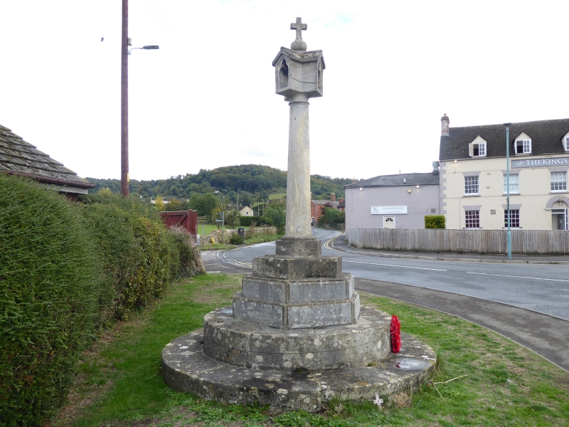
A First World War memorial, dating from circa 1920, altered after the Second World War.
A First World War memorial, dating from circa 1920.
MATERIALS: local Cotswold limestone.
DESCRIPTION: the memorial takes the form of an unusual, wide, cruciform lantern, with a trefoil-headed opening on each side, the lantern designed to house an oil lantern and to show light on all four sides. The lantern has a small orb and cross finial at the top, and stands on a cylindrical Doric column. The column is set on a three-stepped hexagonal base, on a platform of two circular steps. Three faces of the top step of the base have carved lettering picked out in black paint, which reads: OUR / GLORIOUS DEAD / THAT THEIR NAMES / BE NOT FORGOTTEN / 1914 – 1919. Below this, the names of the 25 men who died are carved into inset stone plaques. On the lower step, a further inset plaque reads: 1939 – 1945 / WE WILL REMEMBER THEM; this plaque is flanked by the names of the 14 men who lost their lives.
This List entry has been amended to add the source for War Memorials Online. This source was not used in the compilation of this List entry but is added here as a guide for further reading, 10 January 2017.
The war memorial in King’s Stanley was erected circa 1920, as part of the great wave of commemoration of the sacrifice made by the fallen from communities across the country. The memorial was set up at a prominent location, in the middle of the road at the junction of Broad Street, Church Street and High Street. After the Second World War, the memorial was altered to also commemorate the men of the village who had lost their lives in that conflict.
In 1983, to minimise the risk of damage from traffic, the memorial was moved a short distance to a small grassed area at the roadside. In 2003, the structure was repointed, the lettering recut and stone repairs undertaken with the help of grant aid from War Memorials Trust.
King’s Stanley War Memorial is listed at Grade II, for the following principal reasons:
* Historic interest: as an eloquent witness to the tragic impact of world events on the local community, and the sacrifice it made in the conflicts of the C20;
* Design interest: a well-executed stone memorial, of unusually elaborate form, with a four-sided lantern head which served as a light.
External links are from the relevant listing authority and, where applicable, Wikidata. Wikidata IDs may be related buildings as well as this specific building. If you want to add or update a link, you will need to do so by editing the Wikidata entry.


Other nearby listed buildings
