Approximate Location Map
Large Map »
Latitude: 53.5555 / 53°33'19"N
Longitude: -1.4822 / 1°28'55"W
OS Eastings: 434401
OS Northings: 406669
OS Grid: SE344066
Mapcode National: GBR LW2B.X5
Mapcode Global: WHDCQ.6WGM
Plus Code: 9C5WHG49+64
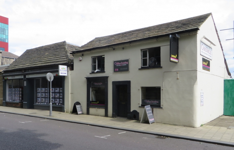
Entry Name: 41-43 Church Street, Barnsley, South Yorkshire
Listing Date: 26 October 2016
Grade: II
Source: Historic England
Source ID: 1435194
ID on this website: 101435194
Location: Barnsley, South Yorkshire, S70
County: Barnsley
Electoral Ward/Division: Central
Parish: Non Civil Parish
Built-Up Area: Barnsley
Traditional County: Yorkshire
Lieutenancy Area (Ceremonial County): South Yorkshire
Church of England Parish: Barnsley St Mary
Church of England Diocese: Leeds
Tagged with: Building
Hall and cross wing house. Later C15, with hall timbers dated by dendrochronology to between AD 1455 and AD 1479, and the cross wing built in or shortly after the winter/spring of AD 1463-4. Late C17 extension of the rear cross wing chamber and a small, lean-to store on east side of hall. Mid- to late C18 alterations due to road remodelling including removal of the timber-framed west elevations and raising of the floor level in the hall and the front chamber of the cross wing and the insertion of a cellar beneath the chamber. 1973 loss of the north service cross wing and two bays of the hall. 2002 renovation of the timber framing and building, with a modern shop front (not of special interest).
Hall and cross wing house. Later C15, with hall timbers dendro-dated between AD 1455 and AD 1479, and the cross wing built in or shortly after the winter/spring of AD 1463-4. Late C17 extension of the rear cross wing chamber and a small, lean-to store on E side of hall. Mid- to late C18 alterations due to road remodelling including removal of the timber-framed west elevations and raising of the floor level in the hall and the front chamber of the cross wing and the insertion of a cellar beneath the chamber. 1973 loss of the N service cross wing and two bays of the hall. 2002 renovation of the timber framing and building, with a modern shop front (not of special interest).
MATERIALS: oak timber frame, hand-made bricks, stone slate roof.
PLAN: a full-height hall, truncated at the N end, running parallel to the road on the W side, with a two-storey, two-chamber cross-wing at its S end. Beneath the front chamber (now full-height) is a cellar. The cross wing has a small, late C17 extension on its S side and store on its N side abutting the E wall of the hall.
EXTERIOR: the front elevation faces W onto Church Street. It has a 2002 single-storey shop front which is not of special interest. Above the modern shop front is a strip of wall approximately four brick rows in height with an overhanging stone slate roof. The roof is double-pitched at the left-hand end, with a N gable wall, and hipped at the right-hand end.
The rear elevation has the projecting E gable wall of the cross wing to the left-hand side with the hall to the right. The outer corner posts of the cross wing stand on squared padstones. The mid-rail has brick infill below, at ground-floor level, and pegged, close studding above rising to the tie beam. In the centre beneath the tie beam is a four-light, timber mullion window. The gable apex also has close studding. The overhanging roof has bargeboards to protect the rafters. On the left-hand side is a flush, two-storey extension of brick with a lean-to roof against the S side elevation which continues the roofline in a catslide. On the right-hand side is a brick extension which projects beyond the gable wall with an angled return to the corner post. It has a lean-to roof against the E wall of the hall. The angled return has a small, rectangular window with a stone lintel and plank shutter. The E face has a doorway with an adjacent small, rectangular window. Both have stone lintels and a plank door and shutter.
The S side elevation is plastered and painted, with a stone boot scraper recessed into the wall (missing the metal scraper). The N side of the cross wing is tile-hung and the N side of the extension and hall is rendered.
INTERIOR: the original timber framing has been patched and badly decayed timbers replaced in a 2002 restoration. The E wall of the hall has timber framing incorporating replacement timbers. There is a mid-rail with a wall below (originally coursed masonry) and close studding above with a blocked, four-light mullion window to the centre. The wall plate has a possible seating for a dais canopy beam. At the right-hand end there is a short flight of steps down to the rear of the building. The king-post truss is constructed as an open truss against the side frame of the parlour cross wing with braces from the main corner posts to the tie beam. The main post for the cross wing truss, which is set in from the hall post, has two mortices which suggest there may have been a heck screen for the former doorway in the SE corner into the rear chamber of the cross wing. The roof structure of rafters, tusk-tenoned purlins and ridge beam continues through the hall and cross wing.
The front and rear chambers of the cross wing are divided by a king-post truss with a main post on its left-hand side. A collar has been added to the W side of the truss probably in the C18 to support the modified roof structure over the front chamber. There is a cross rail beneath the tie beam with mortices for floor joists. The front chamber (now full height) has close studding to the N side (now without infill) with a mid-rail and a diagonal upper brace on the W side to the mid-rail. A large opening has been cut through into the hall. The rear ground-floor chamber has a ceiling with heavy floor joists running E-W, diagonal stone flags on the S side and straight stone flags on the N side. The first-floor chamber has close studding showing at the left-hand end of the N wall. The timber framing is all replaced as this was where a doorway opening had been cut though into the hall. The roof structure has rafters, purlins and a ridge beam. On the S side there is a large beam in the position of a wall plate which supports both the rafters of the original roof and the upper ends of the rafters for the later extension.
The small cellar is beneath the front chamber with narrow stone steps down from the rear chamber. The rectangular room has coursed masonry walls and a barrel-vaulted brick ceiling. There are two niches in the N wall and a former exterior drop in the W wall. It has a stone-flagged floor and a stone table on brick legs.
In 1156 the manor of Barnsley was granted to the Clunaic priory of St John at Pontefract and by the C13 the settlement was relocated to its current position from a position to the NW. The new location took advantage of better communication routes, including the road between Wakefield and Sheffield and the major highway between London and Richmond. The new settlement was laid out in a characteristic medieval form with narrow plots running perpendicularly to the main street and a system of back lanes surrounding the urban plots. The town was centred on a wide market place at Market Hill. Leading N out of Market Hill is Church Street, then known as Kirk Gate, which was one of the main thoroughfares of the medieval town.
The timber-framed building forming Nos 41-43 is located on the E side of Church Street, opposite St Mary’s Church. Dendrochronological evidence suggests that the structure is a later C15 hall with timber felling dates of between AD 1455 and AD 1479 and a cross wing built in or shortly after the winter/spring of AD 1463-4. By this time Barnsley had developed into a sizable community compared to other settlements in the Wapentake of Staincross. The timbers tested showed a felling date spread over a period of 6 years. Timbers at this time were generally used ‘green’ and so the felling date related closely to the construction date of the building. However, the spread of dates here indicates that Barnsley had a well-stocked timber yard rather than the trees being felled for a particular building, which in turn suggests a high demand for building timbers in the town during this period. It also suggests that buildings in Barnsley were usually built of timber, like those in nearby Doncaster, which John Leland, visiting in about 1540, said was ‘builded of wodde’ although there was ‘great plenty of stone there about’. By 1649 a parliamentary survey reported that at Barnsley there was ‘noe wood within the mannor worth valueing’, demonstrating how exhausted local supplies had become. In light of this the Church Street building is a rare survival of a remaining medieval town house in Barnsley. Other timber-framed buildings are known of in the town, but these have largely been demolished, with Nos 41-43 remaining as a rare survival. Deeds registered at Wakefield during the early C18 indicate a number of properties along Church Street were used both as residences and for trade. Nos 41-43 occupied a prime site overlooking one of the busiest thoroughfares in Barnsley and it is possible that their retail usage extends back to the medieval period.
As built, the building appears to have had a 3-bay open hall (of which only the third bay survives with the last truss bearing a carpenter’s mark identifying it as truss IIII). In the E wall plate there is a possible seating for a dais beam for a dais canopy, which would indicate that this was the high end of the hall. On the S side (no. 41) was a 2-bay deep parlour cross wing. There would also have been a cross passage and service wing at the N end, demolished around 1973 and replaced by the present no. 45 Church Street. A doorway in the SE corner of the hall led into the rear chamber of the parlour cross wing. It would have originally contained a staircase and a doorway into the W front chamber. This was heated by a lateral stack, while the rear chamber was unheated. The S and E ground-floor walls were of masonry or brick while the first-floor walls were timber framing and the N side wall was fully framed. This may indicate the existence of a small yard on the E side of the hall.
In the late C17 the rear chamber of the cross wing was enlarged on the S side with the addition of a small 2-storey extension with a lean-to roof. A corner fireplace was also added adjacent to the existing lateral stack in the front chamber. The floor was then flagged with diagonally-set flagstones and at the same time a small store room was added to the E side of the hall with a room over it.
It is probable that a floor was also inserted in the hall either in the late C17 or in the C18 during alterations; at an unknown date a doorway was cut through from the top of the existing staircase in the rear chamber of the cross wing giving access to the higher level of the hall. However, the later loss of part of the timber structure of the hall means that evidence for this occurring is otherwise lacking. During the mid- to late C18 Church Street was remodelled and the ground level raised with the present footpath level 0.9m (3ft) higher. This remodelling resulted in the original timber-framed west front elevations of the hall and cross wing being removed. The change in ground level also meant that the floor level of the hall and the front chamber of the cross wing were raised. This markedly reduced the headroom on the ground floor, although an historic photograph, perhaps dating from the early C20, shows a two-storey front elevation onto Church Street. A cellar was inserted beneath the raised front chamber of the cross wing. A short flight of steps in the SE corner of the hall led down to the doorway through to the rear chamber and store room which retained their original floor level.
The historic photograph appears to show the building with a full double-pitched roof rather than the hipped roof which it now (2016) has at the right-hand end of the street elevation, indicating that the roof structure over the front chamber of the cross wing must have been altered subsequently. The now truncated N end of the hall is also shown. At this time the building looked like two cottages with hung-sash windows and three doorways, one taller adjacent to a shop window at the right-hand end.
In 2002 the building was extensively renovated, being stripped back to the timber frame and the decayed timbers repaired or replaced. The front elevation was given full-height plate glass shop windows with two adjacent doorways to the centre. The timber framing to the rear gable wall was exposed at first-floor level and the brick walls reinstated.
41-43 Church Street, Barnsley, of the later C15 with a small, late C17 extension, mid-late C18 alterations, 1973 alterations, and restored in 2002, is listed at Grade II for the following principal reasons:
* Date: the timbers used to construct the building have been dated by dendrochronology (scientific tree-ring dating) to a felling date of between AD 1455-79 for the hall and AD 1463-64 for the cross wing;
* Architectural interest: as a later C15 vernacular building with close timber-frame studding which is a rare survival of the medieval, timber-framed building tradition in Barnsley;
* Plan form: as a clearly legible medieval open hall and two-storey, two-chamber deep parlour cross wing also demonstrating later social developments in comfort and privacy with the insertion of a hall floor (now removed but retaining a first-floor doorway from the cross chamber), and expansion and additional heating of the cross wing.
External links are from the relevant listing authority and, where applicable, Wikidata. Wikidata IDs may be related buildings as well as this specific building. If you want to add or update a link, you will need to do so by editing the Wikidata entry.


Other nearby listed buildings
