Approximate Location Map
Large Map »
Latitude: 51.9808 / 51°58'51"N
Longitude: -1.0116 / 1°0'41"W
OS Eastings: 467982
OS Northings: 231837
OS Grid: SP679318
Mapcode National: GBR 9XW.P38
Mapcode Global: VHDT8.FG2V
Plus Code: 9C3WXXJQ+89
Entry Name: Gawcott War Memorial
Listing Date: 19 October 2017
Grade: II
Source: Historic England
Source ID: 1449799
ID on this website: 101449799
Location: Holy Trinity Church, Gawcott, Buckinghamshire, MK18
County: Buckinghamshire
Civil Parish: Gawcott with Lenborough
Built-Up Area: Gawcott
Traditional County: Buckinghamshire
Lieutenancy Area (Ceremonial County): Buckinghamshire
Tagged with: War memorial
First World War memorial, designed by W Coles and unveiled 23 April 1922, with later additions for the Second World War.
First World War memorial, 1922, with later additions for the Second World War.
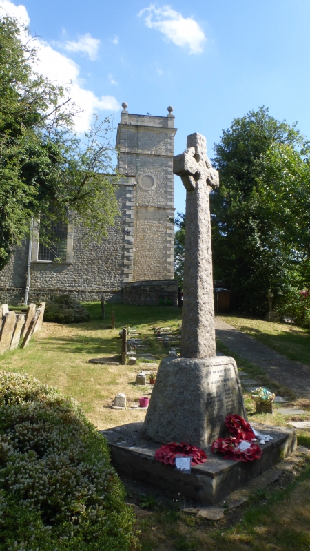
DESCRIPTION: Gawcott War Memorial is located within the churchyard to the north of the Grade II*-listed Church of Holy Trinity.
The memorial is of rough-hewn stone and takes the form of a wheel-head cross on a tapering shaft rising from a tapering, square plinth on a single-step base. The principal inscription is on the west face of the plinth to an inset, smooth stone panel. All lettering is in lead.
The principal inscription reads TO THE GLORY OF GOD/ AND/ IN GRATEFUL REMEMBRANCE/ 1914 – 1919/ (18 NAMES)/ GREATER LOVE HATH NO MAN THAN THIS.
A further inscription commemorating the Second World War is located on an inset panel to the east face of the plinth AND/ IN GRATEFUL/ REMEMBRANCE/ 1939 – 1945/ (2 NAMES).
The aftermath of the First World War saw the biggest single wave of public commemoration ever with tens of thousands of memorials erected across England. This was the result of both the huge impact on communities of the loss of three quarters of a million British lives, and also the official policy of not repatriating the dead which meant that the memorials provided the main focus of the grief felt at this great loss.
One such memorial was raised at Gawcott as a permanent testament to the sacrifice made by the 18 members of the local community who died in service during the First World War. It was unveiled on 23 April 1922 by Major-General Sir George Scott Moncrieff. The designer was W Coles who also created the Grade II-listed war memorial outside the Church of St Peter and St Paul, Buckingham.
Following the Second World War, a dedication was added to commemorate the two casualties of that conflict.
Gawcott war memorial, which is situated in Holy Trinity churchyard, is listed at Grade II for the following principal reasons:
Historic interest:
* As an eloquent witness to the tragic impact of world events on the local community, and the sacrifice it made in the conflicts of the C20.
Architectural interest:
* A well-executed wheel-head cross.
Group value:
* With the Grade II*-listed Church of Holy Trinity.
External links are from the relevant listing authority and, where applicable, Wikidata. Wikidata IDs may be related buildings as well as this specific building. If you want to add or update a link, you will need to do so by editing the Wikidata entry.


Other nearby listed buildings