Approximate Location Map
Large Map »
Latitude: 56.048 / 56°2'52"N
Longitude: -2.7831 / 2°46'59"W
OS Eastings: 351318
OS Northings: 684176
OS Grid: NT513841
Mapcode National: GBR 2R.QYH7
Mapcode Global: WH7TK.67ZW
Plus Code: 9C8V26X8+5Q
Entry Name: Auburn, Manse Road, Dirleton
Listing Name: Dirleton Village, Manse Road, Auburn, Walled Garden and Retaining Wall
Listing Date: 5 February 1971
Category: B
Source: Historic Scotland
Source ID: 331868
Historic Scotland Designation Reference: LB1338
Building Class: Cultural
Also known as: Dirleton, Manse Road, Auburn
ID on this website: 200331868
Location: Dirleton
County: East Lothian
Electoral Ward: North Berwick Coastal
Parish: Dirleton
Traditional County: East Lothian
Tagged with: House
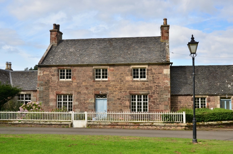
Later 18th century with circa 1840 alterations. 2-storey,
3-bay house with single storey wing. Roughly coursed
rubble; droved ashlar dressings with chamfered arrises
to openings. Raised quoins.
S ELEVATION: doorway at centre with decorative fanlight
and panelled door. Tripartite windows flanking and
bipartites above (circa 1840). Recessed single storey,
4-bay wing to right, with fanlit doorway off-centre to left
with small blocked light to right. Bipartites to remaining
bays.
Rear stair window and addition.
Small-pane glazing pattern to casement and sash and case
windows.
External links are from the relevant listing authority and, where applicable, Wikidata. Wikidata IDs may be related buildings as well as this specific building. If you want to add or update a link, you will need to do so by editing the Wikidata entry.


Other nearby listed buildings
