Approximate Location Map
Large Map »
Latitude: 56.4642 / 56°27'50"N
Longitude: -4.3174 / 4°19'2"W
OS Eastings: 257317
OS Northings: 732632
OS Grid: NN573326
Mapcode National: GBR HCQM.M3Y
Mapcode Global: WH3L4.NSBC
Plus Code: 9C8QFM7M+M3
Entry Name: Burial Ground Of The Macnabs, Innes Bhuidhe, Killin
Listing Name: Killin, Island of Inchbuie (Innis Bhuidhe), Clan Macnab Burial Place Including Screen Wall and Gatepiers
Listing Date: 5 October 1971
Category: B
Source: Historic Scotland
Source ID: 340379
Historic Scotland Designation Reference: LB8277
Building Class: Cultural
Also known as: Killin, Innes Bhuidhe, Burial Ground of The Macnabs
Island Of Inchbuie
Mcnabs
Killin, Innes Bhuidhe, Burial Ground Of The Macnabs
ID on this website: 200340379
Location: Killin
County: Stirling
Electoral Ward: Trossachs and Teith
Parish: Killin
Traditional County: Perthshire
Tagged with: Cemetery Promontory fort
Loch Lomond and Trossachs National Park Planning Authority
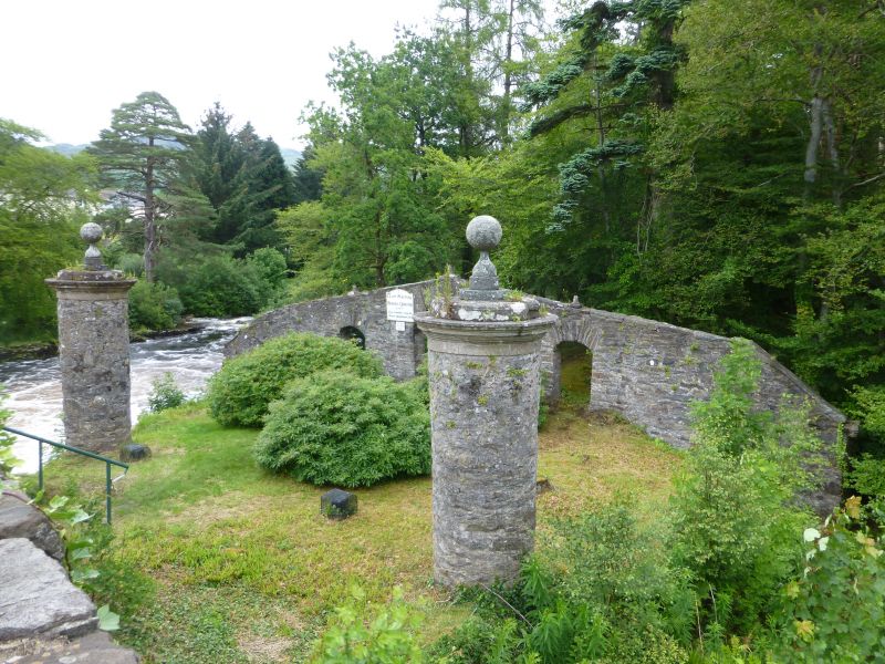
Probably dating largely from the late 18th century, but on a site with ancient origins, this important burial ground is spectacularly located on an island in the Dochart River which is consequently imbued with contemporary Romanticist ideals. Access is from the Bridge of Dochart (see separate listing) where one first encounters a pair of large rubble piers with ball finials before passing through a rubble screen spanning the island with three segmental archways, the largest in the centre. There is the idea of a ceremonial procession before the burial ground containing the graves of the Macnab Clan chiefs is reached. Although the origins of the burial ground are not clear, there is much more here than just a burial place - there is a carefully conceived composition set on an historically important site. The Clan Macnab Burial Ground is therefore not only of interest as a part of Clan history, but it is clearly set apart from its contemporaries and is arguably the epitome of its type.
The burial place itself (which may date from the early 18th century) is at the far end of the island and consists of a near-square rubble enclosure which is open to the elements. There are no openings except on the South elevation which has a central gated entrance flanked by a pair of openings, all segmentally arched. Atop the centre of the walls to the West and East are two stone heads of Neish's or savages, which form part of the Clan crest and the arms of the Chief. There are 15 graves within the burial place itself, nine of them being clan chiefs, including an apparently medieval slab effigy. A grave for 'Finlay Maknab' (d 1573-4) is located there. There are a number of graves also just outside the enclosure.
The central part of the island is a Scheduled Ancient Monument, believed to contain 2 prehistoric forts. It is unclear when Inchbuie was first used as a burial place. It is possible that burials were taking place here from the medieval period onwards but that formalisation of the Island with its processional pathway, screen wall and enclosure was created in the late 18th century as a response to Highland Romanticism. Dorothy Wordsworth was impressed by what she saw in 1814, 'altogether uncommon and romantic - a remnant of ancient grandeur: extreme natural wildness - the sound of roaring water, and withal, the ordinary half-village, half-town bustle of an everyday place'. Early drawings show the island without the present tree cover, making the burial place much more obvious than it is now.
External links are from the relevant listing authority and, where applicable, Wikidata. Wikidata IDs may be related buildings as well as this specific building. If you want to add or update a link, you will need to do so by editing the Wikidata entry.


Other nearby listed buildings
