Approximate Location Map
Large Map »
Latitude: 56.4653 / 56°27'55"N
Longitude: -4.3155 / 4°18'55"W
OS Eastings: 257435
OS Northings: 732756
OS Grid: NN574327
Mapcode National: GBR HCQM.MYR
Mapcode Global: WH3L4.PR6H
Plus Code: 9C8QFM8M+4Q
Entry Name: Railway Viaduct, Killin
Listing Name: Killin, Railway Viaduct over River Dochart
Listing Date: 6 September 1979
Category: A
Source: Historic Scotland
Source ID: 340383
Historic Scotland Designation Reference: LB8281
Building Class: Cultural
Also known as: Killin, Railway Viaduct
ID on this website: 200340383
Location: Killin
County: Stirling
Electoral Ward: Trossachs and Teith
Parish: Killin
Traditional County: Perthshire
Tagged with: Railway viaduct
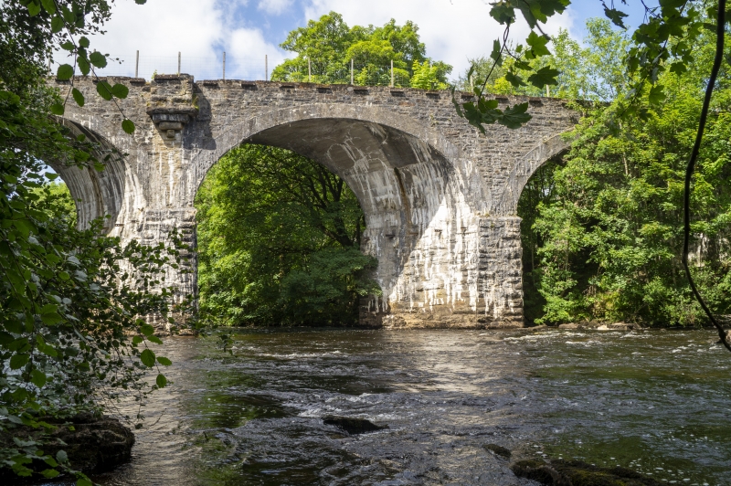
This viaduct is the second oldest mass-concrete constructed railway viaduct in Britain (after the Falls of Cruachan viaduct). Constructed in 1885-6 it is 37ft high and 81 yds long. Composed of 5 skew arches with rubble-faced piers and spandrels and concrete arches, it is a prominent landscape landmark. The subtly crenellated stone parapet has suffered from vandalism and is disappearing in places. Biddle notes that it was part of a short branch line from the main Callander & Oban line intended to complement the tourist potential in Killin itself. It is spectacularly sited and would have provided the rail passengers with an unrivalled view of the Falls of Dochart and the Clan Macnab Burial Place (see separate listing).
The viaduct was upgraded from category B to A on 19PthP June, 1996. It is currently (2004) owned by Kinnell Estate.
External links are from the relevant listing authority and, where applicable, Wikidata. Wikidata IDs may be related buildings as well as this specific building. If you want to add or update a link, you will need to do so by editing the Wikidata entry.


Other nearby listed buildings
