Approximate Location Map
Large Map »
Latitude: 57.5168 / 57°31'0"N
Longitude: -2.7608 / 2°45'38"W
OS Eastings: 354523
OS Northings: 847662
OS Grid: NJ545476
Mapcode National: GBR M8JV.RYV
Mapcode Global: WH7LD.KBKC
Plus Code: 9C9VG68Q+PM
Entry Name: Burnfield
Listing Name: Burnfield Farmhouse
Listing Date: 16 April 1971
Category: C
Source: Historic Scotland
Source ID: 341306
Historic Scotland Designation Reference: LB9053
Building Class: Cultural
ID on this website: 200341306
Location: Huntly
County: Aberdeenshire
Electoral Ward: Huntly, Strathbogie and Howe of Alford
Parish: Huntly
Traditional County: Aberdeenshire
Tagged with: Farmhouse
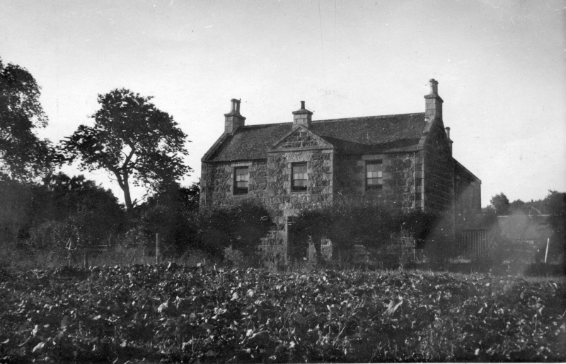
Early 19th century. Large, 2-storey, 3-bay, L-plan, farmhouse with advanced pedimented gabled bay to centre with shouldered stack at apex. Coursed and pinned, roughly squared granite with granite ashlar dressings. Timber panelled door with rectangular fanlight above. Small attic windows to gable ends.
Predominantly replacement 4-pane double-glazing to timber sash and case windows. Grey slate. Ashlar skews and skewputts with thackstanes to chimney bases. Coped gable end stacks with tall octagonal clay cans. Cast-iron rainwater goods.
INTERIOR: Timber staircase with curving timber handrail. Round archway to hall.
Burnfield Farmhouse is a good example of a large, early 19th century Aberdeenshire farmhouse which is prominently located on high ground overlooking the village of Rothiemay. Using local construction methods including pinned granite with a pedimented central bay, it remains largely unaltered externally. Aberdeenshire enjoys a particularly rich agricultural heritage and its early post-improvement farms such as Burnfield provide an important part of the architectural character of the area.
The fire-damaged remains of a simple U-plan steading are located a short distance to the S of Burnfield House (2010).
Burnfield is named on General Roy's military map of 1751, with a small cluster of buildings shown. The L-plan form of the present farmhouse is depicted on the 1st edition Ordnance Survey map of 1856.
Change of category from B to C(S) and list description updated (2010).
External links are from the relevant listing authority and, where applicable, Wikidata. Wikidata IDs may be related buildings as well as this specific building. If you want to add or update a link, you will need to do so by editing the Wikidata entry.


Other nearby listed buildings
