Approximate Location Map
Large Map »
Latitude: 57.5354 / 57°32'7"N
Longitude: -4.5581 / 4°33'29"W
OS Eastings: 246952
OS Northings: 852356
OS Grid: NH469523
Mapcode National: GBR H83T.4TV
Mapcode Global: WH3DS.YVMP
Plus Code: 9C9QGCPR+5P
Entry Name: Fairburn Tower
Listing Name: Fairburn Tower
Listing Date: 25 March 1971
Category: A
Source: Historic Scotland
Source ID: 347288
Historic Scotland Designation Reference: LB14030
Building Class: Cultural
ID on this website: 200347288
Location: Urray
County: Highland
Electoral Ward: Wester Ross, Strathpeffer and Lochalsh
Parish: Urray
Traditional County: Ross-shire
Tagged with: Tower house
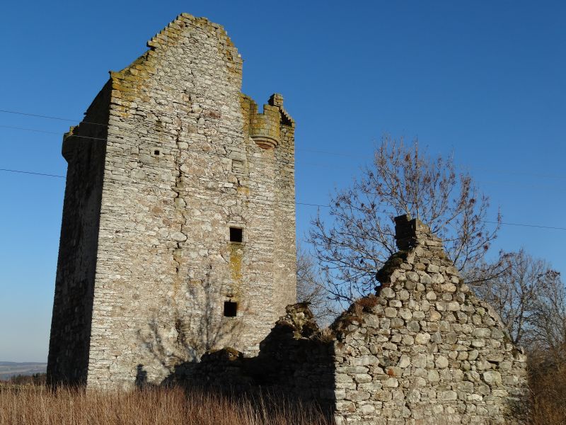
The narrow, square plan tower has four stories (including vaulted basement) and an attic. The walls are of lime pointed and harled rubble. There are gun-loops at the ground floor level. A projecting tower containing a broad circular stair was added to the south side during the 17th-century. The attic level has crow-stepped gables and corbelled-out turrets on the northeast and southwest angles. There is a corniced apex chimney stack to the stair tower.
The vaulted basement was not initially accessible from the exterior and was reached from a straight stair within the north wall. The projecting stair tower masks the earlier first-floor entrance doorway with plain moulded surround. The first floor contains the main hall and several mural closets or wall chambers. Each of the upper floors consists of one room of the same size as the hall, again with several wall chambers.
The tower was restored as holiday accommodation by Simpson and Brown Architects for the Landmark Trust (2020-2022). The spiral staircase and the conical roof turrets have been reintroduced, and the roof recovered with grey slate.
Adjoining the east wall of the tower is the roofless remains (2022) of a two-roomed thatched cottage containing a large arched fireplace with an oven which appears to have been from an earlier kitchen wing.
The tower occupies a commanding position on a hilltop ridge overlooking Strathconon and the Orri valley. A former stronghold of the Mackenzies, the tower was probably built for Murdo Mackenzie after he received a charter for the lands with the understanding that he built a house there.
Listed Building Record revised 2022.
External links are from the relevant listing authority and, where applicable, Wikidata. Wikidata IDs may be related buildings as well as this specific building. If you want to add or update a link, you will need to do so by editing the Wikidata entry.


Other nearby listed buildings
