Approximate Location Map
Large Map »
Latitude: 56.4389 / 56°26'20"N
Longitude: -2.9886 / 2°59'18"W
OS Eastings: 339143
OS Northings: 727850
OS Grid: NO391278
Mapcode National: GBR VK.3CRF
Mapcode Global: WH7RJ.2F46
Plus Code: 9C8VC2Q6+HH
Entry Name: Tay Bridge, Dundee
Listing Name: Tay Railway Bridge
Listing Date: 30 June 1989
Category: A
Source: Historic Scotland
Source ID: 362084
Historic Scotland Designation Reference: LB25681
Building Class: Cultural
Also known as: Tay Bridge
ID on this website: 200362084
Location: Dundee
County: Dundee
Town: Dundee
Electoral Ward: West End
Tagged with: Truss bridge Railway bridge Steel bridge
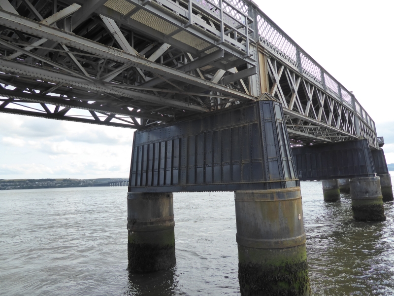
William Henry Barlow, 1882-87, incorporating parts of the first Tay Bridge by Sir Thomas Bouch, 1871-7. Contractors for the first bridge were Charles de Bergue and Co and Hopkinson Gilkes and Co; and for the second, William Arrol and Co. Railway viaduct principally of wrought-iron. Listing covers the full 10,711-feet (3.264km) length of the bridge, including brick viaducts at Newport and Dundee ends and the downstream piers of the first bridge. From S to N.
a) WORMIT: 4 brick arches and piers, 50' spans, widening to S for diversion of lines to Newport and Edinburgh.
b) SOUTH APPROACH, piers 4-28 are twin wrought-iron cylinders lined with brickwork and filled with concrete below water level. Connecting tie of cast and wrought-iron, brick and concrete at high water level. Hollow superstructure of octagonal wrought-iron plate piers linked by an arch. Girders spanning 129 and 145 feet, arranged in 4s, Barlow's 2 new girders sandwiched between Bouch's re-used girders. Both types are of double-triangular wrought-iron. Corrugated-iron and steel decking. Wrought-iron lattice parapet with wooden rail.
c) NAVIGATION SPANS, 13 spans of 245 and 227 feet, on a similar substructure to that of the South Approach. Parabolic hog-backed girders (all by Arrol), above track level give a clearance for ships of 77 feet. Cast-iron segmental arches on cast-iron piers with dated plaques at entrances to navigation sections.
d) NORTH APPROACH, gradient falling towards Dundee, has 37 spans, Nos 42-53 similar to the South Approach. Nos 54-77 curve towards the station, having narrower spans on trabeated cast-iron piers filled with brick and concrete.
e) ESPLANADE SECTION, piers 78-85: 2 wrought-iron skew arches on brick piers over Riverside Drive, then 4 spans of wrought-iron girders on cast-iron columns, grouped in 4s. Later fish-bellied girders cantilevered out to carry station platform.
f) BR DIVISION CIVIL ENGINEER, TAYBRIDGE, OFFICE AND WORKSHOPS (excluding modern building at track level), late 19th century, in place of 100-foot hog-backed girder over original Esplanade. 3 wide arches, red brick with yellow brick bands to N and S elevations. Wrought-iron footbridge on cast-iron columns approaches pedestrian subway.
g) VIADUCT of original bridge inclines to ground level on 34 arches and a ramp. W-most arch has a parapet.
The longest bridge in Britain and perhaps the biggest wrought-iron structure in the world. The high girders of the first bridge blew down on 28.12.1879.
External links are from the relevant listing authority and, where applicable, Wikidata. Wikidata IDs may be related buildings as well as this specific building. If you want to add or update a link, you will need to do so by editing the Wikidata entry.


Other nearby listed buildings
