Approximate Location Map
Large Map »
Latitude: 55.9049 / 55°54'17"N
Longitude: -3.2401 / 3°14'24"W
OS Eastings: 322563
OS Northings: 668670
OS Grid: NT225686
Mapcode National: GBR 8CZ.5R
Mapcode Global: WH6SS.6VB3
Plus Code: 9C7RWQ35+XW
Entry Name: Redford Bridge, Redford Road, Edinburgh
Listing Name: Redford Road, Old Bridge
Listing Date: 14 December 1970
Category: B
Source: Historic Scotland
Source ID: 365315
Historic Scotland Designation Reference: LB27944
Building Class: Cultural
Also known as: Edinburgh, Redford Road, Redford Bridge
ID on this website: 200365315
Location: Edinburgh
County: Edinburgh
Town: Edinburgh
Electoral Ward: Colinton/Fairmilehead
Traditional County: Midlothian
Tagged with: Bridge
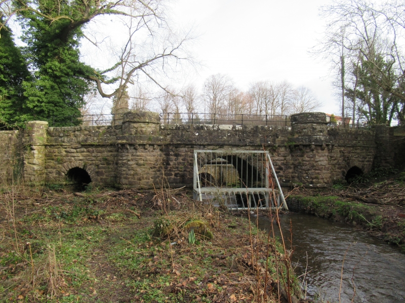
Early 19th century. Triple-arched bridge over Braid Burn with cylindrical piers and raised causeway with parapet walls continuing to W. Coursed sandstone rubble. String course (stonework broken in places). Cylindrical piers with bracketed string course flanking principal central arch. Flanking subsidiary arches (obscured by undergrowth ? 2002) with smaller buttresses to outer left and right. Parapet wall slightly raised over buttresses. Later cast-iron railings between raised sections of wall.
Built for Alexander Trotter, who owned Dreghorn Castle and Redford House during the early nineteenth century. This bridge and Woodend Cottage (listed seperately) are the only buildings of the former Dreghorn estate still standing. The burn flows under the central arch only; the other two arches are silted up and heavily overgrown. An early photograph, from the mid-1840s by David Octavius Hill, shows the bridge in its original condition. The photograph is in the Glasgow University Special Collection, and can be viewed at www.scran.ac.uk. The earliest map that shows a road crossing the Braid Burn at this point is John Laurie?s Plan Of Edinburgh And Places Adjacent, 1766. However, it is not possible to tell on this (or subsequent) maps whether the crossing is by a bridge or a ford. Dreghorn Castle Lodge used to stand at the East of the bridge, but has been demolished.
External links are from the relevant listing authority and, where applicable, Wikidata. Wikidata IDs may be related buildings as well as this specific building. If you want to add or update a link, you will need to do so by editing the Wikidata entry.


Other nearby listed buildings
