Approximate Location Map
Large Map »
Latitude: 55.9485 / 55°56'54"N
Longitude: -3.2056 / 3°12'20"W
OS Eastings: 324807
OS Northings: 673490
OS Grid: NT248734
Mapcode National: GBR 8LH.53
Mapcode Global: WH6SL.QRQ4
Plus Code: 9C7RWQXV+CQ
Entry Name: 7 Castle Terrace, Edinburgh
Listing Name: 5-7 (Inclusive Nos) Castle Terrace, Including Boundary Wall and Railings
Listing Date: 14 December 1970
Category: B
Source: Historic Scotland
Source ID: 366431
Historic Scotland Designation Reference: LB28482
Building Class: Cultural
Also known as: Edinburgh, 7 Castle Terrace
ID on this website: 200366431
Location: Edinburgh
County: Edinburgh
Town: Edinburgh
Electoral Ward: City Centre
Traditional County: Midlothian
Tagged with: Terrace house
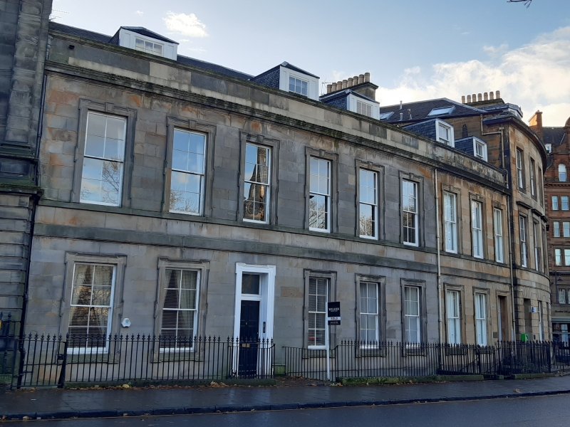
Circa 1850. 2-storey, attic and basement 9-bay curved classical terrace. Cream ashlar, droved to basement. Dividing band between basement and ground and between ground and 1st floors; cill course to 1st floor; eaves cornice and blocking course. Lugged architraves to doors and windows. Stone steps and platts over-arching basement area; timber panelled doors with plate glass fanlights in outer right bay and 3rd bay from left. Piend-roofed slate-hung dormers.
8-pane glazing to timber sash and case windows. Grey slates. Corniced stacks with circular cans.
BOUNDARY WALL AND RAILINGS: spear-headed cast-iron railings on low ashlar boundary wall.
Built on the glebe of St Cuthbert's Church. William Burn produced a feuing plan for the Grindlay Estate in 1825, taking in the glebe. The plan of this area more or less as built appears on Wood's 1820 map of Edinburgh. Thomas Hamilton produced elevations for Castle Terrace in 1825, Burn in 1826. The original design may have been intended to mirror the pavilion at Nos 1 and 2 Castle Terrace, with the quadrant block of Nos 3 and 4 continued as a straight block between. However Bryce's St Mark's Unitarian Church (whose lugged ground floor windows Nos 5-7 and Nos 8-12 Castle Terrace echo), built in 1834, intervened. The roadway, altered to take account of the new Western Approach, was laid in 1831.
External links are from the relevant listing authority and, where applicable, Wikidata. Wikidata IDs may be related buildings as well as this specific building. If you want to add or update a link, you will need to do so by editing the Wikidata entry.


Other nearby listed buildings
