Approximate Location Map
Large Map »
Latitude: 56.1234 / 56°7'24"N
Longitude: -3.9469 / 3°56'48"W
OS Eastings: 279068
OS Northings: 694007
OS Grid: NS790940
Mapcode National: GBR 1C.L78S
Mapcode Global: WH4P6.BCS1
Plus Code: 9C8R43F3+97
Entry Name: Stirling Castle (Comprising): Outer Defences the Counter Guard(1708-14)
Listing Date: 4 November 1965
Category: A
Source: Historic Scotland
Source ID: 387231
Historic Scotland Designation Reference: LB41136
Building Class: Cultural
ID on this website: 200387231
Location: Stirling
County: Stirling
Town: Stirling
Electoral Ward: Stirling North
Traditional County: Stirlingshire
Tagged with: Architectural structure
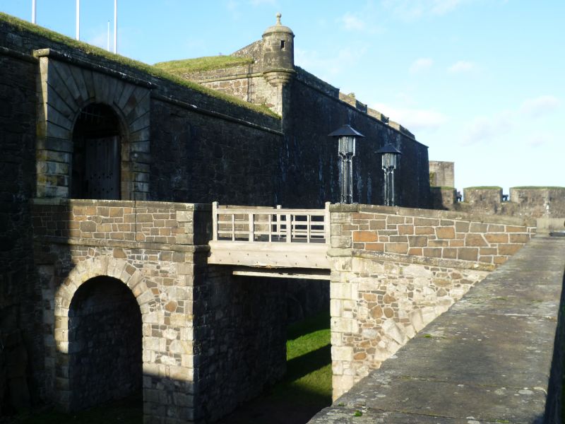
Capt Theodore Dury, engineer James Smith and Talbot Edwards
associated Thomas Bauchop and James Watson, masons, Robert
Mowbray, wright, completed Gilbert Smith from 1711. 1708-14
New Port, Guardroom Square, Over Port, Over Port Battery Spur
and Queen Anne Battery. Early 18th century Renaissance
manner, rubble-built with ashlar dressings.
Scheduled Ancient Monument, No 90291.
External links are from the relevant listing authority and, where applicable, Wikidata. Wikidata IDs may be related buildings as well as this specific building. If you want to add or update a link, you will need to do so by editing the Wikidata entry.


Other nearby listed buildings
