Approximate Location Map
Large Map »
Latitude: 55.9924 / 55°59'32"N
Longitude: -4.8529 / 4°51'10"W
OS Eastings: 222154
OS Northings: 681384
OS Grid: NS221813
Mapcode National: GBR 08.VFRH
Mapcode Global: WH2M2.FN91
Plus Code: 9C7QX4RW+WR
Entry Name: Craigrownie Cottage, Shore Road, Kilcreggan
Listing Name: Shore Road, Craigrownie Cottage with Boundary Wall and Gatepiers
Listing Date: 8 September 1980
Category: B
Source: Historic Scotland
Source ID: 389910
Historic Scotland Designation Reference: LB43433
Building Class: Cultural
Also known as: Kilcreggan, Shore Road, Craigrownie Cottage
ID on this website: 200389910
Location: Cove and Kilcreggan
County: Argyll and Bute
Town: Cove And Kilcreggan
Electoral Ward: Lomond North
Traditional County: Dunbartonshire
Tagged with: Cottage
Mid 19th century foundation with substantial remodelling in early 20th century. 2-storey, gabled, originally L-plan villa, now asymmetrical-plan. Rough harl with sandstone margins and dressings; rough harl with vermiculated honey-coloured sandstone at rear (original cottage), quartz pebble dressings; moulded string course; advanced eaves, exposed rafters.
SW (MAIN) ELEVATION: 3-bay symmetrical main block with 4th recessed entrance bay to outer left. Narrow gabled bay at centre, quartz pebble with partial harl on podium plinth; 2 windows at ground, raised vermiculated cill, shield at centre above; 3 stepped round-headed windows at 1st floor. Flanking bays with large tripartite windows at ground, timber mullions, gabled dormerheads, tripartite windows. Narrow bay recessed to outer left, door at ground, sandstone surround, keystone, timber door with upper panes.
SE ELEVATION: asymmetrical gabled block advanced to outer left, window at ground left, narrow gable abutting to right, door at ground with quartz pebble moulding, plaque with 'cead mille failte? above door, stepped hoodmould, bipartite window above; narrow bay recessed to right, quartz pebble ground floor with single window at 1st floor. Mid 19th century block to abutting to right, jerkin-headed bay, small window at ground, bracketted string course, bipartite round-headed window at 1st floor; tripartite round-headed window in single storey block to right.
NE (REAR) AND NW ELEVATIONS: asymmetrical elevations, rear showing original fabric of cottage.
12-pane and 8-pane over plate glass, plate glass timber sash and case windows. Red tiled roof with swept eaves on later remodelling, terracotta ridging; rendered and coped ridge stacks; grey slate roof with lead flashings, terracotta ridging, ridge stack with vermiculated coping on earlier work.
INTERIOR: not seen 1993.
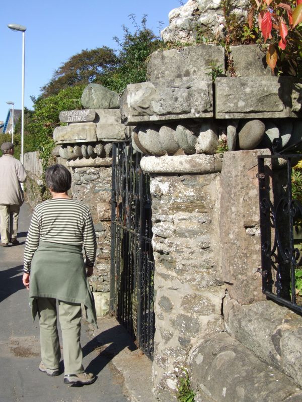
GATEPIERS AND BOUNDARY WALL: stugged, spiralling, horn-like gatepiers, freely-modelled on quartz base. Whinstone plinth wall with droved rubble slab coping, upper balustrade wall pierced with cruciform cast-iron panels, droved slab coping (some panels now infilled with timber).
GATEPIERS (to former stable block): pair of drum piers of whinstone and sandstone with harl pointing, ashlar base; decorative sea pebble collar, rusticated graded cap.
SUNDIAL: simple die sundial of ashlar, stop-chamfered arrises, bronze gnomon and face.
Listed Category B primarily for the particularly unusual gatepiers. Craigrownie Cottage was built on the earliest parcel of feued land by the developer Thomas Forgin. Forgin was also resposible for the feuing of lands on which Cove Cottages, Rocklea, Seymour Lodge and Ferndean were built. The cottage dates from 1837 but was substantially remodelled in the early part of the 20th century. The boundary wall is similar to the boundary wall of Craigrownie Castle, designed by Alexander Thomson in 1850s. The stable block has been substantially altered.
External links are from the relevant listing authority and, where applicable, Wikidata. Wikidata IDs may be related buildings as well as this specific building. If you want to add or update a link, you will need to do so by editing the Wikidata entry.


Other nearby listed buildings
