Approximate Location Map
Large Map »
Latitude: 55.8585 / 55°51'30"N
Longitude: -3.1624 / 3°9'44"W
OS Eastings: 327339
OS Northings: 663425
OS Grid: NT273634
Mapcode National: GBR 60CP.4Q
Mapcode Global: WH6T6.D0CM
Plus Code: 9C7RVR5Q+C3
Entry Name: Manse, 29 Manse Road, Roslin
Listing Name: Roslin, 29 Manse Road
Listing Date: 7 March 1997
Category: B
Source: Historic Scotland
Source ID: 390870
Historic Scotland Designation Reference: LB44176
Building Class: Cultural
ID on this website: 200390870
Location: Lasswade
County: Midlothian
Electoral Ward: Midlothian West
Parish: Lasswade
Traditional County: Midlothian
Tagged with: Manse
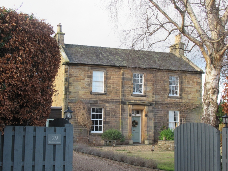
1832 with later addition to NW and garage to SW. 2-storey, symmetrical, 3-bay manse of rectangular plan. Stugged ashlar sandstone to principal elevation and squared sandstone rubble to remainder. Raised, droved margins to windows and polished ashlar door surround. Base course; band course between ground and 1st floor; eaves course; strip quoins to central bay; raised and channelled quoins.
SE (PRINCIPAL) ELEVATION: raised corniced and consoled doorpiece in slightly advanced central bay; timber panelled door with 2-light fanlight above; single window at 1st floor above. Window at each floor in bays to left and right.
NW (REAR) ELEVATION: irregular 5-bay. Lean-to 3-bay addition at ground to right; modern door with fanlight above in left return. Stair window at 1st floor above in bay to centre. Window at 1st floor in bay to outer right. Window at ground in bay to left of centre; non-aligned window at 1st floor above. Window at ground in bay to outer left; non-aligned window at 1st floor above.
SW (SIDE) ELEVATION: mono-pitch boarded garage with 2-leaf, part-glazed boarded doors at ground; gablehead stack above.
NE ELEVATION: blank wall with ashlar coped gablehead stack.
12-pane timber sash and case windows to principal elevation; some modern glazing to rear; grey slate roof; ashlar coped gablehead stacks; ashlar skews; cast-iron rainwater goods.
On the 1st edition OS map, the Manse is affiliated to the neighbouring Chapel of Ease. McWilliam identifies this as the Parish Church, dated 1826, and states that it became the church hall in 1935 (subsequently demolished). The New Statistical Account records the construction of the Manse in 1832 at the expense of the congregation, who also paid for the church and the school-house.
External links are from the relevant listing authority and, where applicable, Wikidata. Wikidata IDs may be related buildings as well as this specific building. If you want to add or update a link, you will need to do so by editing the Wikidata entry.


Other nearby listed buildings
