Approximate Location Map
Large Map »
Latitude: 57.1452 / 57°8'42"N
Longitude: -2.0982 / 2°5'53"W
OS Eastings: 394153
OS Northings: 806033
OS Grid: NJ941060
Mapcode National: GBR SCF.CL
Mapcode Global: WH9QQ.RN1T
Plus Code: 9C9V4WW2+3P
Entry Name: 8 And 10 Trinity Street
Listing Name: 8 and 10 Trinity Street
Listing Date: 27 July 2007
Category: C
Source: Historic Scotland
Source ID: 399607
Historic Scotland Designation Reference: LB50956
Building Class: Cultural
ID on this website: 200399607
Location: Aberdeen
County: Aberdeen
Town: Aberdeen
Electoral Ward: George St/Harbour
Traditional County: Aberdeenshire
Tagged with: Architectural structure
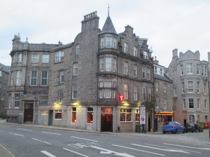
Dated 1900. 3-storey and attic 4 x 3-bay tenement building with altered Public House to ground, situated on prominent corner site with corner 3-light canted bay, corbelled at 2nd storey with polygonal pyramidal roof. Squared and coursed grey granite, rubble to rear. Deep moulded cornice above ground, attic band course. Pair of steeply stepped gables with apex stacks to attic of Trinity Street elevation. Pilasters divide openings to ground. Corner entrance door with moulded doorpiece. Flat-roofed 2-bay section to N with later extension.
Predominantly multi-pane over plate glass timber sash and case windows to upper storeys, non-traditional and plate glass to ground. Grey slates. Gable stacks.
INTERIOR: partially seen at time of resurvey (2006). Ground floor comprehensively modernised.
Dated 1900, this is a well-detailed tenement building situated on a prominent site, visible at entry into Aberdeen city centre from the Railway Station (see separate listing). The multi-pane glazing pattern to the upper sashes is unusual in the city centre and together with the canted corner bay it makes a significant contribution to the streetscape. The 2nd Edition Ordnance Survey Map indicates the presence of a Public House and the ground floor is occupied by one currently (2006).
External links are from the relevant listing authority and, where applicable, Wikidata. Wikidata IDs may be related buildings as well as this specific building. If you want to add or update a link, you will need to do so by editing the Wikidata entry.


Other nearby listed buildings
