Approximate Location Map
Large Map »
Latitude: 52.8072 / 52°48'25"N
Longitude: -3.2102 / 3°12'36"W
OS Eastings: 318517
OS Northings: 323979
OS Grid: SJ185239
Mapcode National: GBR 6X.W6NX
Mapcode Global: WH78W.NPJT
Plus Code: 9C4RRQ4Q+VW
Entry Name: Pont Llangedwyn
Listing Date: 20 October 1952
Last Amended: 23 October 2003
Grade: II
Source: Cadw
Source ID: 605
Building Class: Transport
ID on this website: 300000605
Location: Carrying an unclassified road across the River Tanat ½ km south-west of Llangedwyn Hall.
County: Powys
Community: Llangedwyn
Community: Llangedwyn
Traditional County: Denbighshire
Tagged with: Bridge Road bridge
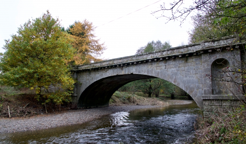
Probably C18. The bridge is likely to have been built or maintained by the Wynnstay estate, who canalised the River Tanat from this position for about 1 km downstream as a feature in the landscaping of Llangedwyn Hall. The decorative features of the bridge are greater on the downstream side facing this improvement.
A bridge of about 15 m span in ashlar masonry with classically derived detailing. Segmental arch in plain voussoirs with no distinction of keystone. Wide and shallow pilasters each side. Square string course at the base of each pilaster and wing and a rounded string course at the base of the parapet. The downstream side is additionally decorated with a corbel course carrying the parapet string course and with round-headed niches in each pilaster. The parapet this side has a slightly projecting coping with pairs of projecting stones at intervals beneath it, dividing the parapet into five panels.
Carriageway about 6 m wide between low parapets. The parapets are slightly turned out at all four ends, and some of the copings have metal cramps.
A fine bridge enhanced to contribute to the landscaped environs of an important house.
External links are from the relevant listing authority and, where applicable, Wikidata. Wikidata IDs may be related buildings as well as this specific building. If you want to add or update a link, you will need to do so by editing the Wikidata entry.


Other nearby listed buildings
