History in Structure

Pont Newydd

A Grade II Listed Building in Nantglyn, Denbighshire

More Photos »
Approximate Location Map
Large Map »

Coordinates

Latitude: 53.1498 / 53°8'59"N

Longitude: -3.4849 / 3°29'5"W

OS Eastings: 300787

OS Northings: 362433

OS Grid: SJ007624

Mapcode National: GBR 6J.5KYL

Mapcode Global: WH662.F3Q4

Plus Code: 9C5R4GX8+W2

Entry Name: Pont Newydd

Listing Date: 19 July 1966

Last Amended: 15 December 1998

Grade: II

Source: Cadw

Source ID: 815

Building Class: Transport

ID on this website: 300000815

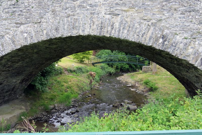
Location: Located some 200m NE of Nantglyn village spanning the Afon Ystrad and carrying the old Denbigh to Nantglyn road immediately E of its modern successor.

County: Denbighshire

Town: Denbigh

Community: Nantglyn

Community: Nantglyn

Locality: Pont Newydd

Traditional County: Denbighshire

Tagged with: Bridge Road bridge

Find accommodation in
Nantglyn

History

First mentioned as Pont Newydd in 1656 and rebuilt in 1726 at a cost of £20. In 1753 £50 was levied to build 'a new stone arched bridge', its predecessor having been 'swept away in the late great flood'. The work was undertaken by Thomas Williams of Llansannan, mason. Further major repairs were undertaken in 1769 at a cost of £120; yet further work was recorded in 1779.

Exterior

Single-span rubble road bridge; wide segmental arch with rough-dressed voussoirs. Plain rubble parapets follow the pronounced hump of the carriageway; limestone coping stones with metal ties. At the Nantglyn end, on the SE side, and on the Denbigh end, on the NW side, are sloping rubble buttresses; the approaches are splayed.

Reasons for Listing

Listed for its special interest as a fine example of an C18 regional bridge.

Group value with the former Rectory adjacent.

External Links

External links are from the relevant listing authority and, where applicable, Wikidata. Wikidata IDs may be related buildings as well as this specific building. If you want to add or update a link, you will need to do so by editing the Wikidata entry.

Recommended Books

Other nearby listed buildings

  • II The Rectory
    Located approximately 1km NE of Nantglyn village, raised up on a bank to the E of the road from Denbigh to Nantglyn; immediately E of the old Pont Newydd. The house is set into a hillslope.
  • II Pont-y-Llan
    Spanning the Afon Ystrad in the centre of the village.
  • II Parish Church of St James
    Located on a raised, near-circular site in the centre of the village; its churchyard contains two ancient yew trees.
  • II Telephone Call-box
    Prominently-located in the village centre, adjoining Cae Llwyd and the Post Office; sited on W side of minor road running uphill from Pont y Llan to N.
  • II Glasmor
    Located prominently on the corner, at the crossroads at the S end of the village street.
  • II Agricultural Range immediately S of Glasmor
    Prominently located at the crossroads at the southern end of the village, opposite Glasmor.
  • II Barn Range to the W of Glasmor
    Prominently located at the crossroads at the southern end of the village, opposite Glasmor.
  • II Waen Presbyterian Chapel and School Hall
    Set back from the road behind rendered rubble forecourt walls with simple surmounting railings; sited into the slope of a hill.

BritishListedBuildings.co.uk is an independent online resource and is not associated with any government department. All government data published here is used under licence. Please do not contact BritishListedBuildings.co.uk for any queries related to any individual listed building, planning permission related to listed buildings or the listing process itself.

British Listed Buildings is a Good Stuff website.