History in Structure

The Coach and Horses PH

A Grade II Listed Building in Castleton, Newport

More Photos »
Approximate Location Map
Large Map »

Coordinates

Latitude: 51.5464 / 51°32'47"N

Longitude: -3.0781 / 3°4'41"W

OS Eastings: 325338

OS Northings: 183610

OS Grid: ST253836

Mapcode National: GBR J2.FVW7

Mapcode Global: VH7BJ.LDLC

Plus Code: 9C3RGWWC+HQ

Entry Name: The Coach and Horses PH

Listing Date: 1 March 1963

Last Amended: 29 February 1996

Grade: II

Source: Cadw

Source ID: 2933

Building Class: Commercial

Also known as: Coach & Horses Inn
Coach & Horses Inn, Cardiff

ID on this website: 300002933

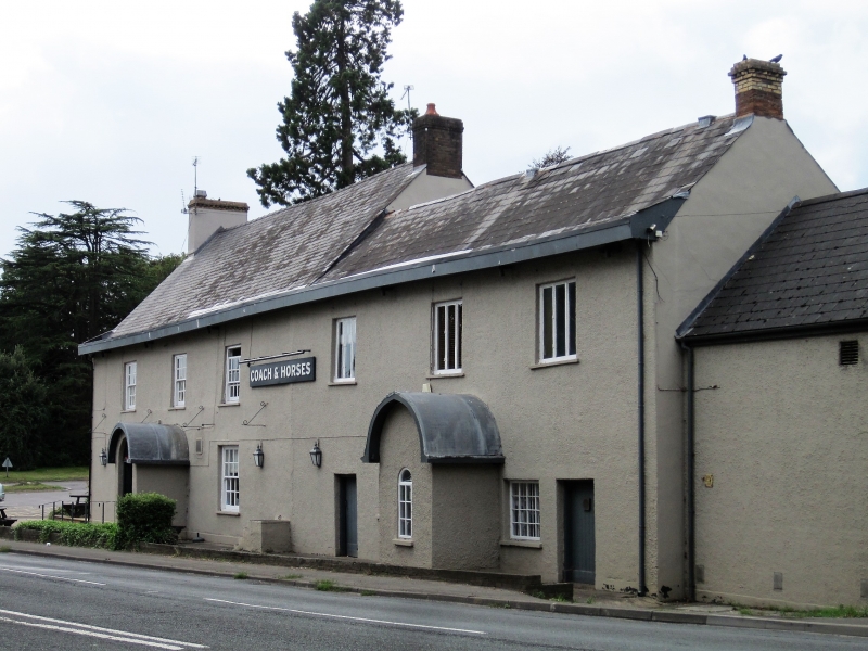
Location: Prominently located on the N side of the A48, aligned on an E/W axis.

County: Newport

Community: Marshfield (Maerun)

Community: Marshfield

Locality: Castleton

Built-Up Area: Castleton

Traditional County: Monmouthshire

Tagged with: Pub

Find accommodation in
Castleton

Exterior

C18 coaching inn, remaining in use as a public house and with modern alterations. Two storey, rendered elevations, steeply pitched slated roof, gable end chimneys, rebuilt in brick. Front (S) elevation of main range is three windows wide, twelve-paned, horned sashes, with modern shutters, central doorway with semi-circular headed porch. Lower, two storey extension running to the E, probably C19, central doorway with matching porch, now blocked. Three, three-light, fixed windows to the first floor, with shutters. Large lean-to extension to the rear with gabled wing at E end.

Interior

Modernised interior, remaining historic features include large open fire places to each end of bar, exposed rubble walling. The timber lintel above the fireplace in the E cell bears the inscription " TAN DDA AELWYD LAN ALODES LAWEN".

Reasons for Listing

Listed notwithstanding modern alterations as a prominently sited inn of C18 origin.

External Links

External links are from the relevant listing authority and, where applicable, Wikidata. Wikidata IDs may be related buildings as well as this specific building. If you want to add or update a link, you will need to do so by editing the Wikidata entry.

Recommended Books

Other nearby listed buildings

  • II Castleton Baptist Church
    Prominently located on corner of the A48 and Marshfield Road. Front is bounded by a dwarf wall with railings and pyramidal capped piers with dentil cornices; low rubble wall to side.
  • II Gelli-ber Farmhouse
    Prominently located on the N side of the A48, aligned on an E/W axis.
  • II* Parish Church of St Mary
    Set on the N side of Church Lane opposite Church Farm, leading off Marshfield Road. The church is surrounded by a low rubble wall with cock and hen coping; lych gate to W and remains of medieval cros
  • II The Old Rectory
    Set on the East side of the lane, opposite the Public House and the Parish Church. Main range is aligned on a NW/SE axis.
  • II* Parish Church of St Michael
    Located at the W side of the village, within a C19 walled enclosure, set behind the public house.
  • II Lodge at Faendre Hall
    By the main entrance gates of Faendre Hall off Vaendre Close; St Mellons golf course is opposite.
  • II Entrance Gateway at Faendre Hall
    Fronting the lane and adjacent to the lodge, forming the entrance to a curved drive to the house.
  • II Former Stable Block at Faendre Hall
    Situated to the rear of the Hall, the drive bifurcating with one section leading to the stables and the other to the Hall.

BritishListedBuildings.co.uk is an independent online resource and is not associated with any government department. All government data published here is used under licence. Please do not contact BritishListedBuildings.co.uk for any queries related to any individual listed building, planning permission related to listed buildings or the listing process itself.

British Listed Buildings is a Good Stuff website.