Latitude: 51.5446 / 51°32'40"N
Longitude: -3.079 / 3°4'44"W
OS Eastings: 325269
OS Northings: 183405
OS Grid: ST252834
Mapcode National: GBR J2.FVLW
Mapcode Global: VH7BJ.LF3S
Plus Code: 9C3RGWVC+R9
Entry Name: Castleton Baptist Church
Listing Date: 29 February 1996
Last Amended: 29 February 1996
Grade: II
Source: Cadw
Source ID: 17227
Building Class: Religious, Ritual and Funerary
Also known as: Castleton Baptist Church
ID on this website: 300017227
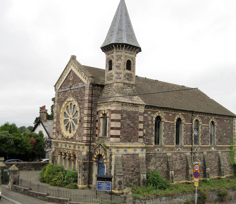
Location: Prominently located on corner of the A48 and Marshfield Road. Front is bounded by a dwarf wall with railings and pyramidal capped piers with dentil cornices; low rubble wall to side.
County: Newport
Community: Marshfield (Maerun)
Community: Marshfield
Locality: Castleton
Built-Up Area: Castleton
Traditional County: Monmouthshire
Tagged with: Chapel Protestant church building
Erected in 1859 and designed by R G Thomas, architect. It is an early example of the Italianate-style chapel facade later developed by George Morgan. Built at a cost of £2,000, the funds for which are said to have been raised by an open-air rally held in Marshfield in 1858 by the famous English non-conformist Charles Haddon Spurgeon.
Eclectic chapel facade in Italianate manner with distinctive rose window and fine polychromatic detailing in cream, blue and red brick. The chapel is constructed of red sandstone and limestone blocks. Clay-tiled gabled roof with bell-tower and spire to NW corner. Central bay of N elevation breaks forward with large rose window with blue and cream striped brickwork surround and ogee-hoodmould with fleur-de-lys finial; two trefoil vents below and similar quatrefoil to gable apex. This central bay has red and cream banded end pilaster strips beneath a blue brick bandcourse and continuous arcading to the gable in Italian Romanesque manner. Below the rose window is a blue and cream diaper pattern frieze over the four vestibule windows with continuous, round-headed, banded arches and foliated capitals. The entrances are set back to either side with similarly banded end pilaster strips and round-arched doorways with nookshafts, ogee hoodmoulds and gabled coping; boarded doors with decorative ironwork. Continuous impost band across front and 2-light windows above both entrances. To right (NW corner) is a polygonal belltower, broached at the base and surmounted by a deeply bracketed slate spire. Four-window, buttressed, side elevations with coloured brick reserved only for the banding of the round-headed windows. Former organ chamber projects at south end (rear) with capped chimney; small rose window and attached school hall and boiler house.
Retains 'U'-shaped gallery supported on slender cast iron columns, originally marbled, now painted grey, and with gilded scrollwork gallery front. Reached from lobby by spiral stone staircases at either end, with simple cast iron handrails. Pews retained. Large open piped organ dating from 1902 behind rose window; former organ chamber at far end blocked. Cast-iron roof trusses with inserted later ceiling.
Listed as a distinctive and well detailed example of a mid C19 chapel.
External links are from the relevant listing authority and, where applicable, Wikidata. Wikidata IDs may be related buildings as well as this specific building. If you want to add or update a link, you will need to do so by editing the Wikidata entry.


Other nearby listed buildings