History in Structure

Ffynnon Fair and Bridge

A Grade II Listed Building in Botwnnog, Gwynedd

More Photos »
Approximate Location Map
Large Map »

Coordinates

Latitude: 52.8509 / 52°51'3"N

Longitude: -4.6349 / 4°38'5"W

OS Eastings: 222670

OS Northings: 331407

OS Grid: SH226314

Mapcode National: GBR 51.SGKW

Mapcode Global: WH33G.SL3S

Plus Code: 9C4QV928+92

Entry Name: Ffynnon Fair and Bridge

Listing Date: 19 October 1971

Last Amended: 11 February 1998

Grade: II

Source: Cadw

Source ID: 4255

Building Class: Domestic

Also known as: Ffynnon Fair and Bridge

ID on this website: 300004255

Location: Beside water meadows, some 50m S of the cross-roads in the centre of Bryncroes village.

County: Gwynedd

Town: Pwllheli

Community: Botwnnog

Community: Botwnnog

Locality: Bryncroes

Traditional County: Caernarfonshire

Tagged with: Bridge Holy well

Find accommodation in
Bryncroes

History

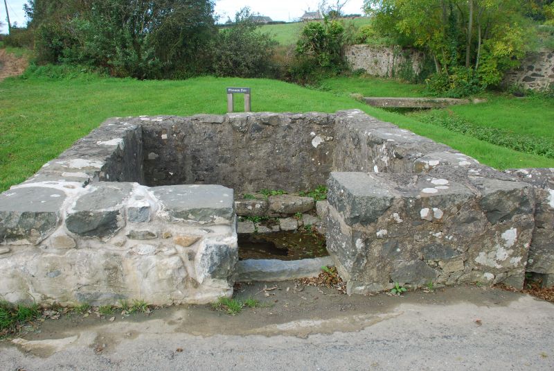
An ancient spring reputed to have been used as a holy well in medieval times, possibly by monks on the pilgrimage route to Bardsey Island.

Exterior

A mortared wall of squared rubble stone with entrance to E, encloses a space some 2.5m square. Inside this enclosure the stone paving descends in two tiered stages forming a pavement around the perimeter of the pool, which measures some 1.2m square. A run-off channel carries surplus water under the boundary wall to the nearby brook.

To the N of the well enclosure is a small bridge. Two water channels cut diagonally across the roadway. Large crudely-worked boulder forms centre support with rectangular openings with slab lintels on either side. Both sides of roadway flanked by low stone wall with raked copings, which curves at the approaches and continues at SW end to join well enclosure to S.

Reasons for Listing

Included as a well-preserved, solidly constructed holy well which, with the adjoining bridge, forms a prominent feature in the centre of Bryncroes village.

External Links

External links are from the relevant listing authority and, where applicable, Wikidata. Wikidata IDs may be related buildings as well as this specific building. If you want to add or update a link, you will need to do so by editing the Wikidata entry.

Recommended Books

Other nearby listed buildings

  • II* Church of St Mary
    In a raised churchyard on the N side of the minor road leading NW from the centre of Bryncroes village to the B 4413.
  • II Letty
    In a walled garden with cobbled flooring on the S side of the minor road which runs S of the churchyard of St Mary, Bryncroes.
  • II Capel Ty Mawr
    Reached along a minor road which runs N of the B4413 some 4 km W of Sarn Meyllteyrn: sited next to the road in a small grassed enclosure, bounded by a low stone wall with ornate wrought-iron gate.
  • II Salem Chapel
    In the village of Sarn Meyllteyrn, in an elevated position facing E, set back from the road in a sloping grassed enclosure bounded at the front by a low wall with cast iron gate and railings.
  • II Trygarn
    Approximately 1.27km S of Sarn Meyllteyrn, approached along a narrow track which runs some 400m SE from the minor road. A barn and possible former chapel are associated with the house.
  • II Pencruga
    Situated about 750m S of Penygroeslon crossroads on E side of road to Rhiw.

BritishListedBuildings.co.uk is an independent online resource and is not associated with any government department. All government data published here is used under licence. Please do not contact BritishListedBuildings.co.uk for any queries related to any individual listed building, planning permission related to listed buildings or the listing process itself.

British Listed Buildings is a Good Stuff website.