Approximate Location Map
Large Map »
Latitude: 52.9358 / 52°56'8"N
Longitude: -4.5211 / 4°31'15"W
OS Eastings: 230664
OS Northings: 340570
OS Grid: SH306405
Mapcode National: GBR 56.M072
Mapcode Global: WH448.JGBQ
Plus Code: 9C4QWFPH+8H
Entry Name: Nefyn Watch Tower
Listing Date: 19 October 1971
Last Amended: 18 June 1998
Grade: II
Source: Cadw
Source ID: 4372
Building Class: Maritime
ID on this website: 300004372
Location: Situated on a mound near the centre of Nefyn, some 60m W of the junction of the A497 and the B4417 and approximately 25m N of the latter.
County: Gwynedd
Town: Pwllheli
Community: Nefyn
Community: Nefyn
Built-Up Area: Nefyn
Traditional County: Caernarfonshire
Tagged with: Watchtower
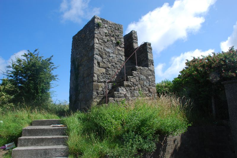
C19 watch tower probably built in connection with the fishing industry. It is shown on the 1889 O.S. map but not marked on the Nefyn Tithe Map of 1838 so is possibly mid C19. It stands on a circular mound which is possibly of an earlier date.
Small square watch tower of rubble stone built on the summit of the remains of a small circular mound some 3m high. Tower is approximately 3m square and some 5m high with a plain parapet 1m high. There are 15 external steps with iron handrail on the landward side turning a right angle after 9 steps to gain the platform.
A rare example of a coastal watch tower, possibly connected with the C19 herring fishing industry of Nefyn.
External links are from the relevant listing authority and, where applicable, Wikidata. Wikidata IDs may be related buildings as well as this specific building. If you want to add or update a link, you will need to do so by editing the Wikidata entry.


Other nearby listed buildings
