Latitude: 52.9359 / 52°56'9"N
Longitude: -4.5201 / 4°31'12"W
OS Eastings: 230728
OS Northings: 340584
OS Grid: SH307405
Mapcode National: GBR 56.M0FL
Mapcode Global: WH448.JGRM
Plus Code: 9C4QWFPH+9W
Entry Name: St Mary's Well
Listing Date: 18 June 1998
Last Amended: 18 June 1998
Grade: II
Source: Cadw
Source ID: 19972
Building Class: Water Supply and Drainage
Also known as: Ffynnon Fair Nefyn
ID on this website: 300019972
Location: Situated prominently near the centre of Nefyn, some 35m N of the junction of the A497 and the B4417.
County: Gwynedd
Town: Pwllheli
Community: Nefyn
Community: Nefyn
Built-Up Area: Nefyn
Traditional County: Caernarfonshire
Tagged with: Architectural structure Well house
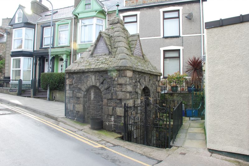
Ornate stone superstructure to the ancient town well, built in 1868 by the Corporation of Nefyn, Robert Thomas and John Jones, bailiffs, according to the inscription, which also records Lord Newborough as mayor and presumably promoter of this unusual building. The well is not listed as a Holy Well in Francis Jones' book 'The Holy Wells of Wales'.
Well superstructure. Squared rubble stone, square plan building with stone pyramidal roof and bronze or copper finial. Sides have blank recessed arch each side with raised rusticated surrounds and raised angle quoins. Plain projecting course above under pyramid roof, which has tooled stone blocks for the angle ridges and a square apex piece under finial. Each face has a stone steep gablet with slate plaque inscribed:
To SW - To NE -
1868 1868
St Mary's Ffynnon
Well Fair
Rebuilt by the Ailadeiladwyd
Corporation of Gan
Nefyn Gorfforaeth Nefyn
Robert Thomas } Robert Thomas}
John Jones } Bailiffs John Jones } Bailiffs
To SE (road front) -
The Right Honourable
Lord Newborough Mayor
Hugh Hughes Deputy Mayor
John Wilson Recorder
Blank plaque and small boarded door to rear. Iron railings and gate on NE, around 4 steps down to sunken area.
Included as a prominent and architecturally elaborate well-house, unusual in the region.
External links are from the relevant listing authority and, where applicable, Wikidata. Wikidata IDs may be related buildings as well as this specific building. If you want to add or update a link, you will need to do so by editing the Wikidata entry.


Other nearby listed buildings