History in Structure

Pont Dol-Rhiw-Felen

A Grade II Listed Building in Ffestiniog, Gwynedd

More Photos »
Approximate Location Map
Large Map »

Coordinates

Latitude: 52.9553 / 52°57'19"N

Longitude: -3.9584 / 3°57'30"W

OS Eastings: 268538

OS Northings: 341566

OS Grid: SH685415

Mapcode National: GBR 5X.KYRP

Mapcode Global: WH55H.5ZB8

Plus Code: 9C4RX24R+4M

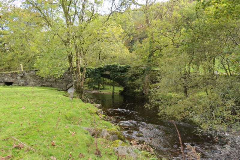
Entry Name: Pont Dol-Rhiw-Felen

Listing Date: 24 April 1951

Last Amended: 1 February 1996

Grade: II

Source: Cadw

Source ID: 14906

Building Class: Transport

ID on this website: 300014906

Location: Spanning a tributary of the Afon Dwyryd about 1km SE of Rhyd-y-sarn at the SW boundary of this community area with that of Maentwrog.

County: Gwynedd

Community: Ffestiniog

Community: Ffestiniog

Locality: Rhyd-y-Sarn

Traditional County: Merionethshire

Find accommodation in
Ffestiniog

Exterior

Spanning a tributary of the Afon Dwyryd about 1km SE of Rhyd-y-sarn at the SW boundary of this community area with that of Maentwrog.

External Links

External links are from the relevant listing authority and, where applicable, Wikidata. Wikidata IDs may be related buildings as well as this specific building. If you want to add or update a link, you will need to do so by editing the Wikidata entry.

Recommended Books

Other nearby listed buildings

  • II Pont Dol-rhiw-felen
    Spanning a tributary of the Afon Teigl, carrying the narrow country road that runs along the N side of the Vale of Ffestiniog between the A487(T) and the B4391; c.2kms ENE of Maentwrog.
  • II* Pont Dol-y-Moch (partly in Maentwrog)
    Spanning the Afon Dwyryd about 1km SE of Rhyd-y-sarn at the SW boundary of Ffestiniog Community with Maentwrog Community, and carrying the narrow lane that runs along the north side of the Vale of Ff
  • II* Pont Dol-y-Moch (partly in Ffestiniog)
    Spanning the Afon Dwyryd about 1km SE of Rhyd-y-sarn at the SW boundary of Ffestiniog Community with Maentwrog Community, and carrying the narrow lane that runs along the north side of the Vale of Ff
  • II Plas Dol-y-moch
    On the narrow country road that runs along the N side of the Vale of Ffestiniog between the A487(T) and the B4391; ENE of Maentwrog.
  • II Cae'n y Coed Uchaf
    On S side of A487 approximately half-way between Maentwrog and Gellilydan. Left (N) gable end to road, small walled foregarden to front of house.
  • II Penralltgoch
    Located approximately 0.5km W of Ffestiniog village on a slightly raised terrace on the steep roadside.
  • II Dduallt (also known as Plas y Dduallt)
    In an isolated rural location raised high above the N side of the narrow country road that runs along the N side of the Vale of Ffestiniog between the A487(T) and the B4391; ENE of Maentwrog.
  • II Church of St Michael
    On a promontory of high ground at the western end of Llan Ffestiniog, set back slightly from the informal village square.

BritishListedBuildings.co.uk is an independent online resource and is not associated with any government department. All government data published here is used under licence. Please do not contact BritishListedBuildings.co.uk for any queries related to any individual listed building, planning permission related to listed buildings or the listing process itself.

British Listed Buildings is a Good Stuff website.