Approximate Location Map
Large Map »
Latitude: 52.8326 / 52°49'57"N
Longitude: -4.126 / 4°7'33"W
OS Eastings: 256873
OS Northings: 328241
OS Grid: SH568282
Mapcode National: GBR 5Q.TL5L
Mapcode Global: WH565.L2G8
Plus Code: 9C4QRVMF+3H
Entry Name: Church of St Tanwg
Listing Date: 30 November 1966
Last Amended: 23 May 2003
Grade: I
Source: Cadw
Source ID: 4790
Building Class: Religious, Ritual and Funerary
Also known as: St Lanwg's Church
ID on this website: 300004790
Location: Located at the coast to SSW end of the village of Llandanwg.
County: Gwynedd
Community: Llanfair
Community: Llanfair
Locality: Llandanwg
Traditional County: Merionethshire
Tagged with: Church building
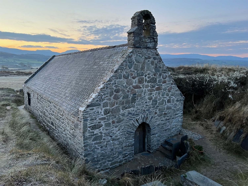
Early Medieval church, extended to E in C14. Restored in late C17 when The E window was rebuilt and other windows altered; this was probably when the W doorway was inserted, a choir loft was dismantled and the 2 supporting floor beams moved to the back of the church to support the gallery. The floor was flagged in 1786 and some of the ornate Medieval paintings were destroyed when the walls were replastered and painted.
In 1839 a new parish church was built in Harlech and the C15 font, bell and other furnishings removed from Llandanwg; the church fell into disuse in 1845 and by late C19 was in a ruinous condition. Restored by the Society for the Preservation of Ancient Buildings in 1884 for £80. Further work was done both prior to and following World War II and in 1987 a major restoration was completed for £20,000.
Medieval parish church comprising continuous nave and chancel, single bellcote at W gable. Built of roughly coursed rubble masonry with large stones as quoins and stone dressings. Slate roof with rough stone copings. The entrance is at the W end through a pointed arched doorway with radiating quoins, scars in the masonry above the entrance suggest that there was formerly a gabled porch. The E window was originally a tall pointed arched window, now only the moulded label with facial stops remains; the opening is partially blocked, now with a 3-light mullioned window towards the base.
The S lateral wall has a blocked opening to W end which has an arched head of radiating quoins under an advanced stone as label. To E end there are 2 rectangular openings with paired timber framed lights. Along the N lateral wall there is a partially blocked doorway to W end which now houses a rectangular window with cusped trefoil lights and a square hoodmould with weathered facial stops; there is a blocked window to it''s R (W).
Undivided nave and chancel; the roof is of 6-bays with arch braced collared trusses, the 3 easternmost bays have cusped windbraces and the E bay shows signs of a former barrel roof over the sanctuary. There is a weathered cross beam which formed the top of the rood screen to the E end and at the far W end there are the gallery support beams (formerly part of the choir loft) which have rounded moulded soffits. The sanctuary has a plain rail and is raised by a single step. Set within the sill of the S sanctuary window is part of a C6 gravestone which bears the inscription: EQUESTRINOMINE. Another inscribed stone lies by the altar which bears 2 names: the first reads INGENI, the second has been defaced but may read ENNB... (for ENNBAR). Part of a gravestone is built into the W gable above and to R of the doorway, probably C7 - C9. It bears a roughly incised cross and has had the intitials and date: REP 1685 added (probably when the doorway was inserted).
Listed at Grade I as a remarkable church of very early origins and simple Medieval character, which retains many early features including some fine carpentry within the roof.
External links are from the relevant listing authority and, where applicable, Wikidata. Wikidata IDs may be related buildings as well as this specific building. If you want to add or update a link, you will need to do so by editing the Wikidata entry.


Other nearby listed buildings
