Latitude: 53.3246 / 53°19'28"N
Longitude: -4.5515 / 4°33'5"W
OS Eastings: 230163
OS Northings: 383894
OS Grid: SH301838
Mapcode National: GBR HM4X.FWJ
Mapcode Global: WH42B.1PWM
Plus Code: 9C5Q8CFX+VC
Entry Name: Church of St Mwrog
Listing Date: 5 April 1971
Last Amended: 16 February 2001
Grade: II
Source: Cadw
Source ID: 5304
Building Class: Religious, Ritual and Funerary
Also known as: St Mwrog's Church, Llanfwrog
ID on this website: 300005304
Location: Set back from the SW side of the road at the S end of the village of Llanfwrog.
County: Isle of Anglesey
Town: Holyhead
Community: Llanfaethlu
Community: Llanfaethlu
Locality: Llanfwrog
Traditional County: Anglesey
Tagged with: Church building
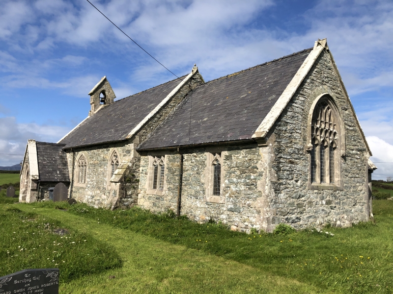
Mid C19 church, replacing an earlier building and perhaps incorporating some of its fabric. The reconstruction was the work of Henry Kennedy and Rodgers in 1864.
C19 church in late Perpendicular style. Nave of 3 bays with W gable bellcote and SW gabled porch; shorter narrower chancel with N vestry. The church is built of local rubble masonry with freestone dressings; modern slate roof with narrow courses below a slate ridge, and stone copings.
The nave has offset angled buttresses at the E end and there is a single gabled bellcote at the W end above reset weathered facial stops set at the apex of the gable; the E gables have weathered trefoil finials. The windows are a mix of 1, 2 and 3 trefoil-headed lights with arched heads. The chancel has similarly detailed windows with flat heads, the E window has 3 trefoil-headed lights and Perpendicular tracery in a pointed arch with hoodmould terminating in facial label stops. Entry to the church is through the SW porch: chamfered arches to outer and inner doorways, and boarded inner door with ornate floriate hinges; the W wall of the porch has a single pointed-arched window. The vestry has a pointed arched door in the W wall and a single rectangular window with paired lights under a relieving arch in the N wall.
The nave has a roof of 5 bays with exposed rafters and purlins and king post trusses with braces carried down to wall posts on simple shaped corbels. The chancel roof is of a single bay with exposed collared rafters; chancel is raised by 2 steps and has a simple chancel arch with stop-chamfered angles. The sanctuary has a simple timber rail on twisted iron stanchions with floriate brackets. The fittings are all C19, presumably contemporary with the building of the church. At the W end of the nave is an octagonal font thought, by RCAHM, to be medieval, re-dressed. There is a late C19 slate memorial tablet on the N wall and an early C20 bronze memorial tablet on the S wall.
Listed as a small C19 rural church, perhaps deriving its simple form and Perpendicular style from its predecessor, of which a few fragments remain.
External links are from the relevant listing authority and, where applicable, Wikidata. Wikidata IDs may be related buildings as well as this specific building. If you want to add or update a link, you will need to do so by editing the Wikidata entry.


Other nearby listed buildings