Approximate Location Map
Large Map »
Latitude: 51.7455 / 51°44'43"N
Longitude: -4.7684 / 4°46'6"W
OS Eastings: 208981
OS Northings: 208832
OS Grid: SN089088
Mapcode National: GBR GC.N46K
Mapcode Global: VH2PC.9DH6
Plus Code: 9C3QP6WJ+6J
Entry Name: Reynalton Church
Listing Date: 21 June 1971
Last Amended: 18 March 1997
Grade: II
Source: Cadw
Source ID: 6091
Building Class: Religious, Ritual and Funerary
ID on this website: 300006091
Location: At the NW of Reynalton village, in a small churchyard N of the village street.
County: Pembrokeshire
Town: Kilgetty
Community: Kilgetty/Begelly (Cilgeti/Begeli)
Community: Kilgetty/Begelly
Locality: Reynalton Village
Traditional County: Pembrokeshire
Tagged with: Church building
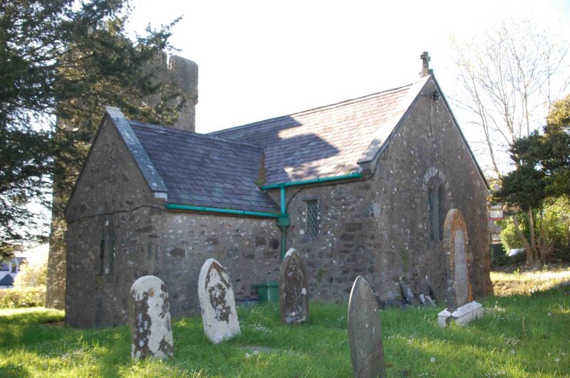
A mediaeval church, taken to be dedicated to St. James. In the time of Henry VIII it was stated to have been appropriated to the Priory of Haverfordwest. Although much restored, it retains its original tower and also stairs in the S transept which led to its rood loft or possibly an upper storey in a lost porch. A blocked doorway in the W wall of the transept suggests the latter. It was restored in the late C19, either late in the incumbency of the Rev. J D Palmer or in the time of the Rev. J J Phillips. The living was united with Jeffreyston in 1900.
Nave and chancel in one, with a S transept and a small tower. Its only door is to the S, without a porch. The church is built of uncoarsed local sandstone masonry, and there are traces of old render on the N faced of the nave and chancel. The E wall of the chancel is battered slightly at the foot. The tower is in a similar masonry but has large quoin stones for about two thirds of its height, so the top third may have been rebuilt. In he S wall of the navet here is a straight joint to the left of the doorway, at a position where a wall of a lost porch may have existed.
The roof is of thick slates and tile ridges. Coped gables, with a final cross at the E.
The windows are probably all C19. Generally they are pairs of lancets under a relieving arch. In the S wall of the chancel there is a single square-headed window. In the W wall of the tower there is a pair of square-headed windows giving light to the apex of the vaulted lower storey. The door in the S wall is of the C19, with a four-centred arch formed of two stones. There are hooks in the outside face of the wall for a lost external door.
The tower is a small example of the local traditional style, of two storeys. A parapet projects on corbels on all sides, but the undersides of the corbels are splayed instead of taking the usual quarter-round form. The belfry lights are square-headed with large slate louvres, on all faces. The staircase turret rises to the upper storey but, unusually in the local tradition, not to the roof. It has a separate roof with a gable to the N.
The chancel and the nave are continuous with no chancel arch. The roof is all of the C19 restoration, with collar beam trusses. Plastered and whitewashed walls. Two steps up at the sanctuary. E of the transept there is a high level corbel possibly from a former roof structure. The transept opens into the nave by a low rudely formed segmental arch. In the transept are steep disused stairs against the W side. C19 pews; some earlier C19 pews remain in the transept. The vaulted base of the tower opens directly to the nave. There are no inscriptions.
Listed as a simple mediaeval church much restored in the late C19, but retaining some original features.
External links are from the relevant listing authority and, where applicable, Wikidata. Wikidata IDs may be related buildings as well as this specific building. If you want to add or update a link, you will need to do so by editing the Wikidata entry.


Other nearby listed buildings
