Latitude: 51.6722 / 51°40'19"N
Longitude: -4.6966 / 4°41'47"W
OS Eastings: 213634
OS Northings: 200487
OS Grid: SN136004
Mapcode National: GBR GF.7R4Z
Mapcode Global: VH2PS.J7YG
Plus Code: 9C3QM8C3+V9
Entry Name: The Harbour Master's Office
Listing Date: 26 April 1977
Last Amended: 28 March 2002
Grade: II
Source: Cadw
Source ID: 6221
Building Class: Maritime
ID on this website: 300006221
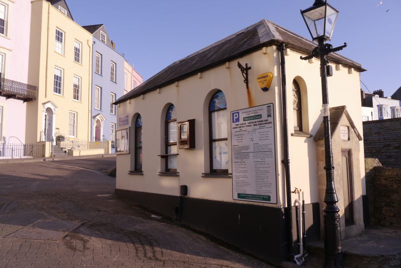
Location: Situated at the top of Pier Hill on the W side of Castle Square.
County: Pembrokeshire
Town: Tenby
Community: Tenby (Dinbych-y-pysgod)
Community: Tenby
Built-Up Area: Tenby
Traditional County: Pembrokeshire
Tagged with: Office building
C19 small harbour building, presently the harbourmasters office. Possibly rebuilt in 1874, in 1861 there was a weighhouse on the site when the existing barometer in a Bath stone case was set up, but in 1874 plans for a new harbourmaster's office to cost £90 are mentioned, suggesting that it was then rebuilt. Restored in late C20.
Harbourmaster's office, painted stucco and slate hipped roof, the gutters carried on small rectangular corbels. Small single-storey building with raised plinth, 3 arched windows to E side, S end arched doorway set to left with single step up and small arched niche to right. W side has shallow canted bay window. Against N end wall is a barometer in a gabled ashlar case inscribed 'Presented by Charles Allen Esq 1861'. All windows and door renewed in late C20.
Included as a small harbour building of historical interest and of group value with surrounding listed items.
External links are from the relevant listing authority and, where applicable, Wikidata. Wikidata IDs may be related buildings as well as this specific building. If you want to add or update a link, you will need to do so by editing the Wikidata entry.


Other nearby listed buildings