Approximate Location Map
Large Map »
Latitude: 51.6721 / 51°40'19"N
Longitude: -4.6967 / 4°41'48"W
OS Eastings: 213626
OS Northings: 200480
OS Grid: SN136004
Mapcode National: GBR GF.7R3X
Mapcode Global: VH2PS.J7WH
Plus Code: 9C3QM8C3+R8
Entry Name: Former Fishermen's Rooms
Listing Date: 3 March 1961
Last Amended: 28 March 2002
Grade: II
Source: Cadw
Source ID: 6154
Building Class: Domestic
ID on this website: 300006154
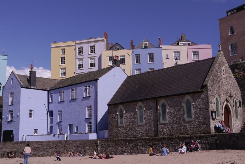
Location: On the hill from the harbour to Castle Square just NE of St Julian's Seaman's Church.
County: Pembrokeshire
Town: Tenby
Community: Tenby (Dinbych-y-pysgod)
Community: Tenby
Built-Up Area: Tenby
Traditional County: Pembrokeshire
Tagged with: Architectural structure
Three-storey L-plan building built in 1874 by W Newton-Dunn of Tenby as Fishermens' Rooms. Builder Wm Davies, of Tenby. The accounts suggest that subscriptions were raised in 1872 for Reading Rooms and existing buildings were purchased to which alterations were made. The money was largely given by Miss Forde. When opened they were described as having 4 public rooms, one for men, one for youths, a classroom and library and an evening room for fisher boys and the boys of the Quay Street school. The cost was £800, which suggests a new building. The architect gave the plans free. In 1876 tenders were advertised for additions to cost £310 to be built by William Davies of Tenby to Dunn's plans. The building was converted into flats in later C20, known as No 1 (Top Deck), No 2 (Quarter Deck), No 3 (Seamens Rooms) and No 4 (Down Below).
Flats, former Fishermens' Rooms, painted roughcast with slate close-eaved roofs and C20 small black brick chimneys. Three storeys, L-plan with later C20 glazing to all windows on N front to harbour. N front has crosswing to left with coped shouldered gable and left side-wall stack. Tiny attic light, long second floor window and shorter first floor window. Wide boatstore entry below with sliding door. Ground and first floor narrow windows on right side wall. Main range has to extreme left a tall cambered headed 2-storey narrow opening to stairway to No 3, and narrow 2nd floor window above. Other 3 bays have 3 large square second floor windows and 2 narrower windows to ground and first floors aligned slightly further out than the outer windows of the top 3. Ground floor has square-headed door and small arched window aligned with middle of 3 upper windows. Right end gable is also roughcast and has 12-pane horned sash to each upper floor right and small C20 stack.
S elevation to slope of Penniless Cove Hill is of rubble stone and single-storey only with 2 gabled entries breaking eaves. Entrance to No 1 in gable-end of crosswing to right: Coped shouldered gable over offset pointed doorway with 3-pane overlight and double 2-panel doors. Red brick jambs and pointed head of red brick with Bath stone keystone and springing stones. In gable is a raised brick panel on 2 corbels, of uncertain purpose. Entrance to No 2 is to left of centre in main range and has C20 door and 16-pane sash window both set under pair of similar brick and ashlar pointed arches with date stone 1874 above, and coped gable. Red brick jambs, and brick under window sill, cemented tympana to arches.
Included as prominent building in the harbour, of social historical interest.
External links are from the relevant listing authority and, where applicable, Wikidata. Wikidata IDs may be related buildings as well as this specific building. If you want to add or update a link, you will need to do so by editing the Wikidata entry.


Other nearby listed buildings
