Approximate Location Map
Large Map »
Latitude: 51.7988 / 51°47'55"N
Longitude: -4.7328 / 4°43'58"W
OS Eastings: 211656
OS Northings: 214662
OS Grid: SN116146
Mapcode National: GBR CW.XYJ0
Mapcode Global: VH2P5.X19V
Plus Code: 9C3QQ7X8+GV
Entry Name: Greenway Farm
Listing Date: 17 May 1988
Last Amended: 17 May 1988
Grade: II
Source: Cadw
Source ID: 6517
Building Class: Domestic
ID on this website: 300006517
Location: Gable end to the roadside 300 yds NW from the junction with Kiln Park Road.
County: Pembrokeshire
Community: Narberth (Arberth)
Community: Narberth
Built-Up Area: Narberth
Traditional County: Pembrokeshire
Tagged with: Architectural structure
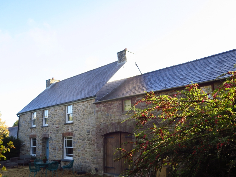
Late C18 2 storey and attic, 3 window vernacular farmhouse. Limewashed random rubble masonry. Steeply pitched roof of quarry slates in diminishing courses. Rendered squat stone stacks with water tabling. Plain close eaves and verges.
Victorian sash windows to 1st floor set under eaves. Ground floor windows enlarged in C19; cambered brick voussoirs, sidebars to Victorian sash windows. Plain reveals, slate sills.
Central doorway square headed, C19 door. Modern glazed porch. Over projection with lean-to roof to extreme left.
Tier of 3 windows to left of left hand gable end, concrete lintel on ground floor timber to attic and 1st floors. Victorian sashes to ground floor and attic, 1st floor window partly blocked stone sills. Right gable end slate hung.
12 small pane sash window to left of outshot, timber lintel, stone sill. Later broad cambered brick voussoir arch to doorway below; plank door, narrow windows alongside under arch. Outshot has blocked loft window cambered ground floor opening at rear.
Outhouse adjoining at right angles to rear. Gabled slate roof, random rubble masonry. Originally with doorway to both ends. Later brick voussoir arches, blocked on right with boiler chimney inserted and 12 pane sash window alongside. Split door to doorway, small buttresses flanking. Vent slit to front and rear wall. Formerly cowhouse later partly converted to boiler house.
External links are from the relevant listing authority and, where applicable, Wikidata. Wikidata IDs may be related buildings as well as this specific building. If you want to add or update a link, you will need to do so by editing the Wikidata entry.


Other nearby listed buildings
