History in Structure

Gilead Old Chapel

A Grade II Listed Building in Hundleton, Pembrokeshire

More Photos »
Approximate Location Map
Large Map »

Coordinates

Latitude: 51.657 / 51°39'25"N

Longitude: -4.936 / 4°56'9"W

OS Eastings: 197013

OS Northings: 199435

OS Grid: SR970994

Mapcode National: GBR G8.FMYT

Mapcode Global: VH1S6.DMC4

Plus Code: 9C3QM347+QH

Entry Name: Gilead Old Chapel

Listing Date: 29 September 1993

Last Amended: 29 September 1993

Grade: II

Source: Cadw

Source ID: 6572

Building Class: Religious, Ritual and Funerary

Also known as: Gilead Old Chapel, Maiden Wells

ID on this website: 300006572

Location: Situated on NW side of main road. Opposite the present Gilead Chapel.

County: Pembrokeshire

Community: Hundleton

Community: Hundleton

Traditional County: Pembrokeshire

Tagged with: Chapel

Find accommodation in
Saint Twynnells

Exterior

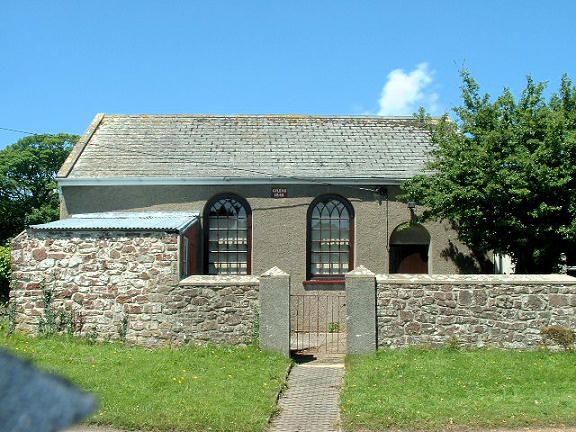
1845 former Calvinistic Methodist Chapel, now hall. Roughcast with slate roof. Single-storey lateral facade with two big arched windows, small-paned with intersecting tracery in heads; round arched door to right with blank tympanum and framed ledged door. Door to left within added rubble stone lean-to. Centre plaque: 'Gilead 1845'. Coped end gables, slate hanging in SW gable.

Rubble stone front wall with rendered piers.

Reasons for Listing

Included as good example of smaller rural chapel of earlier C19. Replaced by present chapel of 1876 across the road.

External Links

External links are from the relevant listing authority and, where applicable, Wikidata. Wikidata IDs may be related buildings as well as this specific building. If you want to add or update a link, you will need to do so by editing the Wikidata entry.

Recommended Books

Other nearby listed buildings

  • II Rose Lodge
    Situated opposite W end of unadopted road from Maiden Wells, on W side of lane to Bowett Farm.
  • II North Lodge
    Situated at head of main drive to Orielton Field Centre, on E side of drive.
  • II Brick Hall
    Situated in walled garden just W of main drive to Orielton Field Centre.
  • II Orielton Gardens
    Situated some 600m S of main gates to Orielton Field Centre from Clay Lane, outside NE corner of main walled garden.
  • II Walls of Two Walled Gardens including Dog Kennels at Brick Hall
    Situated immediately S of road, and mostly to W of Brick Hall which stands within the E walled garden.
  • II Walls of walled garden to SE of Orielton Home Farm
    Situated some 250m NE of Orielton Field Centre, on S side of rear drive.
  • II Yerbeston Farmhouse
    Situated on E side of road from St Petrox to Maiden Wells, some 500m N of St Petrox.
  • II Orielton Field Centre
    Situated on E side of rear drive, some 100m N of house. Early C19 stable court comprising ornamental entrance block with detached U-plan courtyard ranges to rear, now converted for use by Field Centr

BritishListedBuildings.co.uk is an independent online resource and is not associated with any government department. All government data published here is used under licence. Please do not contact BritishListedBuildings.co.uk for any queries related to any individual listed building, planning permission related to listed buildings or the listing process itself.

British Listed Buildings is a Good Stuff website.