Latitude: 51.8184 / 51°49'6"N
Longitude: -3.1137 / 3°6'49"W
OS Eastings: 323331
OS Northings: 213892
OS Grid: SO233138
Mapcode National: GBR F1.WQ91
Mapcode Global: VH6CP.ZK8D
Plus Code: 9C3RRV9P+9G
Entry Name: Clydach House
Listing Date: 19 July 1963
Last Amended: 27 July 2000
Grade: II*
Source: Cadw
Source ID: 6667
Building Class: Domestic
Also known as: Clydach House, Llanelly
ID on this website: 300006667
Location: Situated on sharp bend of by-road between Maesygwartha and the A465, opposite the garage at Saleyard. Approximately 1.5 km SW of Maesygwartha.
County: Monmouthshire
Community: Llanelly (Llanelli)
Community: Llanelly
Locality: Clydach
Traditional County: Brecknockshire
Tagged with: House
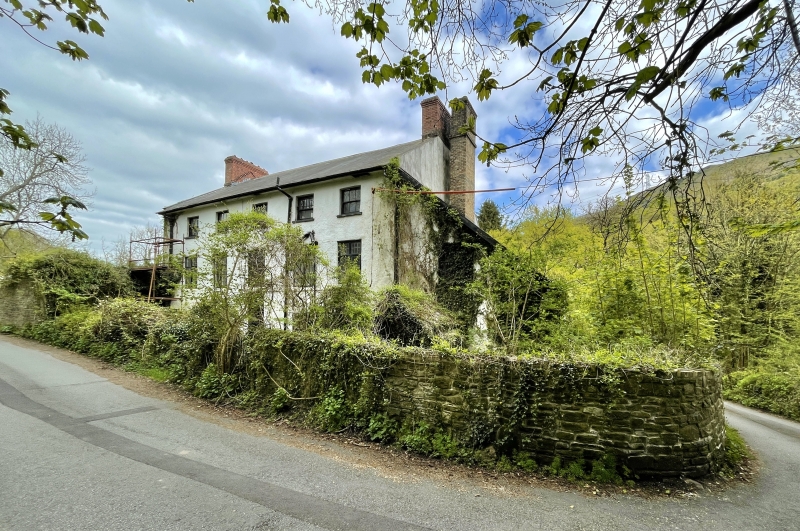
Built 1693 for Francis Lewis, manager of the Llanelly Furnace. House is dated with the arms of Lewis over the front door. Second storey added in early C19, when the entrance facade was given sash windows. The rear retains several late C17 cross-windows, an unusually rare survival. The iron furnace was established by Major John Hanbury, and was certainly in production by 1684. Francis Lewis, who built Clydach House in 1693. The furnace was charcoal-powered and by 1704, Hanbury was preparing to produce 300 tons of iron per year. In 1717, the furnace was reckoned to be capable of producing 400 tons per year, and by c. 1720, it was claimed to produce about 25 tons a week in a 40-week campaign. The works closed at the end of the C18, superseded by the coke-fired ironworks at Clydach, set up by 1793.
Rendered limewashed elevations. Broad slate roof on deep eaves. Large brick gable chimney stacks; also stack to left lean-to in line with house chimney. Right stack slightly projects. Entrance front of five bays and three storeys, the upper storey added in early C19. Twelve-pane sash windows to lower storeys within plain painted architraves; six-pane upper sashes. Central entrance with elaborate heraldic tablet overhead with rounded top. Tablet contains arms of Lewis, with several quarterings including Cadogan Fychan, a Welsh prince who died in 1111. Underneath are the initials of Francis Lewis and ‘anno domini 1693’ Broad lofted lean-to to left with upper 15:15:15 pane casement. In front of lean-to is single storey wing with monopitch slate roof, the latter facing the road; door facing garden. Left end of house shows later brickwork to gable, evidence of the addition of the upper storey. C20 windows below to lean-to. Five-bay rear elevation has upper 6-pane sashes. First floor has rare surviving timber cross-windows of 1693 with leaded glazing; shorter upper panes. Ground floor has two similar windows to right, and taller central cross window lighting stair, set at higher level. Two 12-pane sashes to left. Lean-to to right has upper casement over gabled porch which has slate roof.
Not available for inspection, but known to have a fine open-well central stair of 1693 with twisted balusters.
Listed at Grade II* as a remarkably well-preserved ironworks manager’s house, dated 1693, retaining original detail including rear cross-windows, and staircase, as well as much detail of the early C19. One of the earliest and most important surviving buildings of the important industrial landscape of the Clydach Gorge.
External links are from the relevant listing authority and, where applicable, Wikidata. Wikidata IDs may be related buildings as well as this specific building. If you want to add or update a link, you will need to do so by editing the Wikidata entry.


Other nearby listed buildings