Approximate Location Map
Large Map »
Latitude: 52.1124 / 52°6'44"N
Longitude: -3.3545 / 3°21'16"W
OS Eastings: 307338
OS Northings: 246879
OS Grid: SO073468
Mapcode National: GBR YQ.94JT
Mapcode Global: VH6B6.S5YF
Plus Code: 9C4R4J6W+X5
Entry Name: Church of St Maritius
Listing Date: 23 March 1962
Last Amended: 3 August 2001
Grade: II
Source: Cadw
Source ID: 6704
Building Class: Religious, Ritual and Funerary
ID on this website: 300006704
Location: Situated in small churchyard, reached by short lane up to NW from A470 some 120m N of Abernant.
County: Powys
Town: Builth Wells
Community: Erwood (Errwd)
Community: Erwood
Locality: Alltmawr
Traditional County: Brecknockshire
Tagged with: Church building
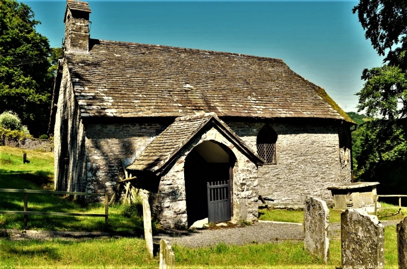
Small parish church of uncertain date, medieval origins but probably rebuilt in C18 and with C19 chancel and earlier C20 repairs. Nave of some 35 ft (10.68m) is one of the smallest in Wales.
Church, rubble stone with stone-tiled roofs. Small nave with gabled W bellcote, S porch and apsidal small chancel. NE vestry. Detail is all C19 or earlier C20, timber windows to nave. 3 with flat heads, leaded lights and shouldered arched heads to each light: two-light W window, single light and 2-light to nave N. Added lean-to plain N vestry with slate roof and E lancet window. Nave S has gabled stone porch with plastered roof inside, stone bench seats and earlier C20 door in segmental pointed surround. One pointed nave S window with 2-light timber Y-tracery.
Chancel has canted sides and taller E wall, each with pointed small lancet in rock-faced stone surround, the E lancet set higher. Rock-faced quoins.
Plastered whitewashed walls, plastered 3-sided ceiling with 3 tie-beam trusses, ceiled at collar level, two with angle struts. Slate floor. Plain bench pews with square-headed panelled bench-ends, 2 box-pews at W end and one larger private pew at NW corner with high sides and seats within on 3 sides. Six pews on N side, second with fielded panel end, sixth with fielded panels to back, facing square enclosure in front of pulpit. Pulpit has plain 3-sided panel front with book-rest. N side has pews and then 2-sided reading desk with book-rest. Chancel has seats built into two window recesses with Jacobean-style panelled backs and scrolled arm rests. Similar detail to low oak reredos, all more probably earlier C20 than C17. Plain oak rails. Heavily retooled round font on octagonal shaft, possibly C13, said to come from Aberedw. W end plaque to T. Weal of Cwrt Gwenddwr (d 1822), signed Davies of Builth, in 2 colours with urn. Unusual electroplate or gilded metal plaque to Sir Alfred T. Lawrence, 1st Baron Trevethin, of Abernant, 1843-1936, Lord Chief Justice 1921-2, with portrait of himself and his wife taken from a wedding portrait of 1875, signed Ernest Gillick.
Included as a miniature parish church of unusual character, with some Georgian style box-pews
External links are from the relevant listing authority and, where applicable, Wikidata. Wikidata IDs may be related buildings as well as this specific building. If you want to add or update a link, you will need to do so by editing the Wikidata entry.


Other nearby listed buildings
