History in Structure

Fine Fare

A Grade II Listed Building in Hay-on-Wye, Powys

More Photos »
Approximate Location Map
Large Map »

Coordinates

Latitude: 52.0738 / 52°4'25"N

Longitude: -3.1269 / 3°7'36"W

OS Eastings: 322862

OS Northings: 242316

OS Grid: SO228423

Mapcode National: GBR F1.CF0N

Mapcode Global: VH6BJ.R49J

Plus Code: 9C4R3VFF+G7

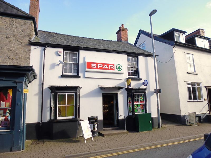
Entry Name: Fine Fare

Listing Date: 1 February 1988

Last Amended: 1 February 1988

Grade: II

Source: Cadw

Source ID: 7339

Building Class: Commercial

ID on this website: 300007339

Location: Set back on the corner with Back Fold; No 27 adjoins forward to left. Formerly the Mason's Arms PH.

County: Powys

Community: Hay (Y Gelli Gandryll)

Community: Hay

Built-Up Area: Hay-on-Wye

Traditional County: Brecknockshire

Tagged with: Building

Find accommodation in
Hay-on-Wye

History

C17 origins, heightened and altered in C19.

Exterior

2-storey and attic, 2-window rendered front with high plinth. Slate roof and brick chimney stacks; swept roof dormer to centre. Recessed 12-pane sash windows to 1st floor; later sash glazing to splayed bays below with moulded cornices flanking off-centre modern door with bracket hood.

Whitewashed rubble right end with slightly battered base, set in the slope of back fold; the rear roof verge is steeper and slightly lower representing the original pitch. Cross range extends to rear slightly stepped out beyond casement and sash windows and then further back splayed out to depth of massive chimney breast with tall stone stack. Smaller brick stack at rear with slate roof lean-to beyond gable end of cross range which has projecting purlin ends.

Interior

One truss visible on 1st floor with moulded knee below the beam. Feather stop chamfer purlins to attic; boarded doors.

Reasons for Listing

Group value with neighbouring listed items in Castle Street.

External Links

External links are from the relevant listing authority and, where applicable, Wikidata. Wikidata IDs may be related buildings as well as this specific building. If you want to add or update a link, you will need to do so by editing the Wikidata entry.

Recommended Books

Other nearby listed buildings

  • II J.Geoffrey Aspin
    Set into a continuous row of street frontages stepped up from adjoining properties.
  • II H.R.Grant including former Flannel mill to rear
    Set into a row of street frontages, stepped up from the adjoining properties. The mill extends at an angle to rear set in the slope and end on to Belmont road.
  • II Steve Davies Domestic Appliances
    Part of a small group towards the corner with Belmont Road, stepped down from No 6. No 8 was formerly the Dog Inn and later the Talbot Inn.
  • II Hay Cottage Bakery
    Part of a small group towards the corner with Belmont Road, stepped down from No 6.
  • II Outbuilding Range to SW of Hay Castle
    Immediately to SW of the Castle House attached by a lintel to a former doorway across the angle. Entered from the service courtyard opposite the former coach house and stable range.
  • II Former Coach-House & Stable Range to Hay Castle
    Attached to the SW end of the Castle House and splayed forward with the yard to rear; screened from the garden by a rubble wall, partly broken down.
  • II Section of the Boundry Wall to Hay Castle
    Adjoining No 30 at SW end and continuing to the corner with the Market Place; set in the slope.
  • II Belmont House
    Set back at the top of the street at the junction with Castle street; railed forecourt.

BritishListedBuildings.co.uk is an independent online resource and is not associated with any government department. All government data published here is used under licence. Please do not contact BritishListedBuildings.co.uk for any queries related to any individual listed building, planning permission related to listed buildings or the listing process itself.

British Listed Buildings is a Good Stuff website.